HIGHWAY 1 INFORMATION
UPDATE #29 (1/21/2025)
FINAL REMINDER
FULL OVERNIGHT CLOSURE OF HIGHWAY 1 AT ROCKY CREEK FOR CONCRETE BRIDGE DECK POUR BEGINS TUESDAY JANUARY 21 AT 10 PM
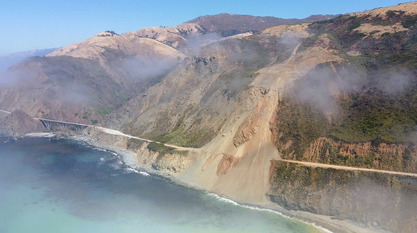
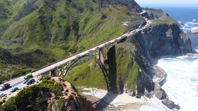
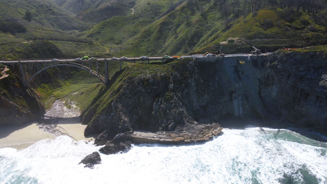
MONTEREY COUNTY – Caltrans is continuing with emergency repairs to Highway 1 near the Rocky Creek Bridge, 12 miles south of Carmel. Caltrans previously stabilized and reinforced Highway 1 at this location after a March 30, 2024, slipout resulted in a loss of a section of the southbound lane.
Full Overnight Closure Starts Tuesday January 21 at 10 pm
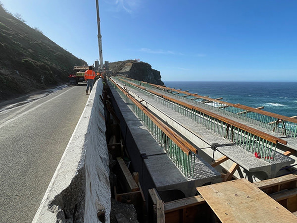
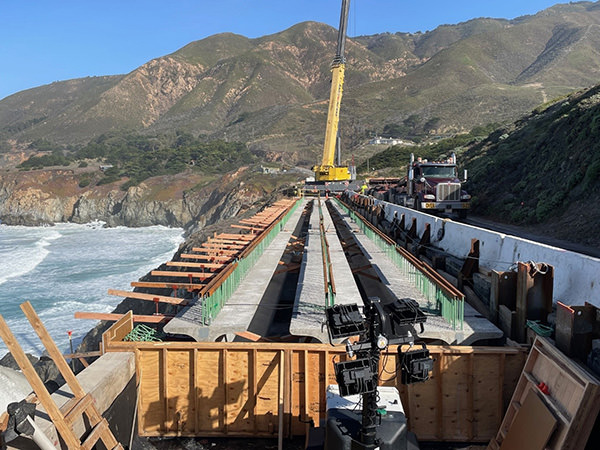
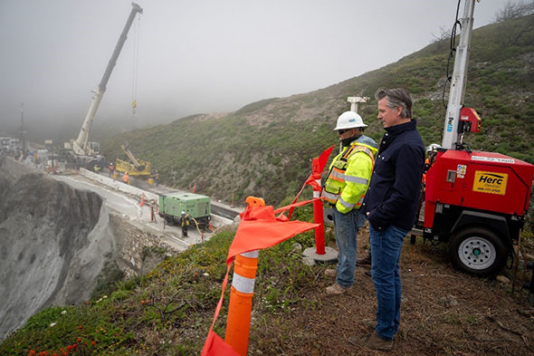
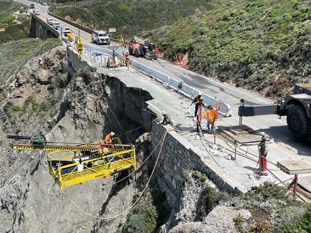
After a mid-December 2024 installation of concrete girders, crews will pour the concrete bridge deck for the southbound lane of the Rocky Creek viaduct during an overnight closure of Highway 1. Travelers will encounter a full closure of Highway 1 at Rocky Creek on Tuesday, January 21, 2025, from 10 pm to 6 am.
Flaggers will begin intermittent traffic control with delays of up to 10 minutes at 8:30 pm before the full closure goes into effect.
Starting at 10:00 pm crews will close Highway 1 completely and stage concrete pumps in the northbound lane to pour concrete for the bridge deck until 6 am.
The schedule for this concrete bridge deck pour is weather dependent. Updates will be provided to confirm or announce any changes to this schedule.
The estimate for completion of the Rocky Creek viaduct is summer 2025 and is dependent on conditions encountered during construction. The contractor for this project is Gordon N. Ball, Inc. of Walnut Creek, CA.
Although Highway 1 remains closed 40 miles south of Carmel due to the Regent’s Slide, travelers from northern California are still able to visit the Big Sur coast and its historic bridges, waterfalls, restaurants, and lodging amenities.
Travelers to the Big Sur coast from southern California will also encounter a closure of the coast highway at Regent’s Slide but are still able to reach the unparalleled views, lodging amenities, and natural wonders along Highway 1 when they visit Lucia, the Camaldoli Hermitage, Gorda, Ragged Point, San Simeon, and Cambria. The vast majority of the Big Sur coast remains accessible and open.
Road information and updates can also be found on Caltrans District 5 Social Media platforms: X/Twitter at: @CaltransD5, Facebook at: Caltrans Central Coast (District 5) and Instagram at: Caltrans_D5.
Our crews deserve to get home safely too.
Drive slowly and carefully in work zones.
CHP Traffic Incident Information Page: http://cad.chp.ca.gov
Traveler information at: https://quickmap.dot.ca.gov/
UPDATE #27 (1/9/2025)
FULL OVERNIGHT CLOSURE OF HIGHWAY 1 AT ROCKY CREEK FOR CONCRETE BRIDGE DECK POUR BEGINS TUESDAY JANUARY 21 AT 10 PM
MONTEREY COUNTY – Caltrans is continuing with emergency repairs to Highway 1 near the Rocky Creek Bridge, 12 miles south of Carmel. Caltrans previously stabilized and reinforced Highway 1 at this location after a March 30, 2024, slipout resulted in a loss of a section of the southbound lane.
Full Overnight Closure Starts Tuesday January 21 at 10 pm
After a mid-December 2024 installation of concrete girders, crews will pour the concrete bridge deck for the southbound lane of the Rocky Creek viaduct during an overnight closure of Highway 1. Travelers will encounter a full closure of Highway 1 at Rocky Creek on Tuesday, January 21, 2025, from 10 pm to 6 am.
Flaggers will begin intermittent traffic control with delays of up to 10 minutes at 8:30 pm before the full closure goes into effect.
Starting at 10:00 pm crews will close Highway 1 completely and stage concrete pumps in the northbound lane to pour concrete for the bridge deck until 6 am.
The schedule for this concrete bridge deck pour is weather dependent. Updates will be provided to confirm or announce any changes to this schedule.
The estimate for completion of the Rocky Creek viaduct is summer 2025 and is dependent on conditions encountered during construction. The contractor for this project is Gordon N. Ball, Inc. of Walnut Creek, CA.
Although Highway 1 remains closed 40 miles south of Carmel due to the Regent’s Slide, travelers from northern California are still able to visit the Big Sur coast and its historic bridges, waterfalls, restaurants, and lodging amenities.
Travelers to the Big Sur coast from southern California will also encounter a closure of the coast highway at Regent’s Slide but are still able to reach the unparalleled views, lodging amenities, and natural wonders along Highway 1 when they visit Lucia, the Camaldoli Hermitage, Gorda, Ragged Point, San Simeon, and Cambria. The vast majority of the Big Sur coast remains accessible and open.
UPDATE #24 (12/11/2024)
FULL 24-HOUR CLOSURE OF HIGHWAY 1 AT ROCKY CREEK
MOVED DUE TO FORECASTED WINDS
HARD CLOSURE TO NOW START SATURDAY, DECEMBER 14 AT 10 PM
MONTEREY COUNTY – Due to winds forecasted to gust beyond the threshold limits for the operation of cranes, Caltrans has moved the 24-hour full closure of Highway 1 at Rocky Creek from its previously announced start date of Friday, Dec. 13.
Caltrans is now scheduled to fully close Highway 1 at Rocky Creek for 24 hours starting Saturday, Dec. 14 at 10 pm. Highway 1 is scheduled to reopen to thru travel on Sunday, Dec. 15 at 10 pm.
Rocky Creek is located 12 miles south of Carmel. No vehicle travel of any kind will be possible on Highway 1 through Rocky Creek for the duration of this 24-hour closure.
During this full 24-hour closure crews will install nine pre-cast concrete girders as progress advances on construction of a viaduct to replace a section of the southbound lane lost due to a slipout on March 30.
Two heavy cranes will be in operation at either end of the project area during the girder installation and no vehicle travel through the site will be possible.
Highway 1 remains closed at Regent’s Slide, 40 miles south of Carmel.
UPDATE #20 (11/13/2024)
NO OVERNIGHT CLOSURES OF HIGHWAY 1 AT ROCKY CREEK SCHEDULED THROUGH DECEMBER 12
MONTEREY COUNTY – Caltrans will continue with emergency repairs to Highway 1 near the Rocky Creek Bridge, 12 miles south of Carmel. Caltrans previously stabilized and reinforced Highway 1 at this location after a March 30 slipout resulted in a loss of a section of the southbound lane.
Upcoming Repair Schedule
- No overnight closures of Highway 1 at Rocky Creek are scheduled through Thursday, Dec. 12. Crews continue to make substantial progress on construction involving the drilling and casting of reinforced concrete columns to support the weight of the viaduct structure. This phase of construction will continue during daytime hours.
- Daytime travelers can expect intermittent delays of up to 20 minutes as crews bring equipment on site for continued construction activities.
Once construction of the southbound section of the Rocky Creek viaduct is complete, travel will be directed onto this southbound section and work will begin on construction of the northbound portion of the viaduct.
The estimate for completion of the Rocky Creek viaduct is summer 2025 and is dependent on conditions encountered during construction. The contractor for this project is Gordon N. Ball, Inc. of Alamo, CA.
Although Highway 1 remains closed 40 miles south of Carmel due to the Regent’s Slide, travelers from northern California are still able to visit the Big Sur coast and its historic bridges, waterfalls, restaurants, and lodging amenities.
Travelers to the Big Sur coast from Southern California will also encounter a closure of the coast highway at Regent’s Slide but are still able to reach the unparalleled views and natural wonders along Highway 1 when they visit Lucia, the Camaldoli Hermitage, Gorda, Ragged Point, San Simeon, and Cambria. The vast majority of the Big Sur coast remains accessible and open.
UPDATE #19 (11/11/2024)
OVERNIGHT CLOSURES ON HIGHWAY 1 AT ROCKY CREEK HAVE BEEN CANCELLED FOR MONDAY 10/11 AND TUESDAY 10/12
MONTEREY COUNTY – Caltrans will continue with emergency repairs to Highway 1 near the Rocky Creek Bridge, 12 miles south of Carmel. Caltrans previously stabilized and reinforced Highway 1 at this location after a March 30 slipout resulted in a loss of a section of the southbound lane.
Upcoming Repair Schedule
- Full overnight closures, originally scheduled for Monday, Nov. 11 and Tuesday, Nov. 12 have been cancelled. Crews were able to complete all phases of work requiring the use of a crane. No overnight closures are expected through the rest of this week.
- Daytime travelers can expect intermittent delays of up to 20 minutes as crews bring equipment on site for continued construction activities.
Once construction of the southbound section of the Rocky Creek viaduct is complete, travel will be directed onto this southbound section and work will begin on construction of the northbound portion of the viaduct.
The estimate for completion of the Rocky Creek viaduct is summer 2025 and is dependent on conditions encountered during construction. The contractor for this project is Gordon N. Ball, Inc. of Alamo, CA.
Highway 1 remains closed 40 miles south of Carmel due to the Regent’s Slide. However, the vast majority of the Big Sur coast remains accessible and open.
UPDATE #19 (11/6/2024)
THREE FULL OVERNIGHT CLOSURES FOR HIGHWAY 1 AT ROCKY CREEK WITH SUNDAY 10/10 AND MONDAY 10/11 TO START ONE HOUR EARLIER
MONTEREY COUNTY – Caltrans will continue with emergency repairs to Highway 1 near the Rocky Creek Bridge, 12 miles south of Carmel. Caltrans previously stabilized and reinforced Highway 1 at this location after a March 30 slipout resulted in a loss of a section of the southbound lane.
Upcoming Repair Schedule
Crews have made substantial progress in a construction phase involving the drilling and casting of reinforced concrete columns to support the weight of the viaduct structure. Due to the need for a large crane and other heavy equipment to span the roadway during upcoming construction activities, travelers will encounter full overnight closures in addition to intermittent daytime closures. The overnight closure schedule is weather dependent, and updates will be provided as needed if wind speeds exceed thresholds for crane operations.
- There will be full overnight closures of Hwy. 1 at Rocky Creek on Wednesday, Nov. 6, and Thursday, Nov. 7, from 10 pm to 6 am.
- As previously announced, there will be full overnight closures of Hwy. 1 at Rocky Creek on Sunday, Nov. 10, and Monday Nov. 11. Please note earlier start time for Sunday and Monday from 9 pm to 6 am.
- There will be a full overnight closure of Hwy. 1 at Rocky Creek on Tuesday, Nov. 12 from 10 pm to 6 am.
- Daytime travelers can expect intermittent delays of up to 20 minutes as crews bring equipment on site for continued construction activities.
Once construction of the southbound section of the Rocky Creek viaduct is complete, travel will be directed onto this southbound section and work will begin on construction of the northbound portion of the viaduct.
The estimate for completion of the Rocky Creek viaduct is summer 2025 and is dependent on conditions encountered during construction. The contractor for this project is Gordon N. Ball, Inc. of Alamo, CA.
Highway 1 remains closed 40 miles south of Carmel due to the Regent’s Slide. However, the vast majority of the Big Sur coast remains accessible and open.
UPDATE #17 (11/4/2024)
TUESDAY NOVEMBER 4 FULL OVERNIGHT CLOSURE ADDED TO THIS WEEK'S SCHEDULE FOR HIGHWAY 1 AT ROCKY CREEK
MONTEREY COUNTY – Caltrans will continue with emergency repairs to Highway 1 near the Rocky Creek Bridge, 12 miles south of Carmel. Caltrans previously stabilized and reinforced Highway 1 at this location after a March 30 slipout resulted in a loss of a section of the southbound lane.
Upcoming Repair Schedule
Crews have made substantial progress on a construction phase involving the drilling and casting of reinforced concrete columns to support the weight of the viaduct structure. Due to the need for a large crane and other heavy equipment to span the roadway during upcoming construction activities, travelers will encounter full overnight closures in addition to intermittent daytime closures. The overnight closure schedule is weather dependent, and updates will be provided as needed if wind speeds exceed thresholds for crane operations.
Due to a need to employ a large crane for an additional shift, a full overnight closure of Hwy. 1 at Rocky Creek has been added to the week of November 4 on Tuesday, Nov. 5. Full overnight closures at Rocky Creek are now scheduled for Monday, Nov. 4, Tuesday, Nov. 5, Wednesday, Nov. 6, and Thursday, Nov. 7, from 10 pm to 6 am.
- Full overnight closures of Hwy. 1 at Rocky Creek are also scheduled for Sunday, Nov. 10, and Monday Nov. 11, from 10 pm to 6 am.
- Daytime travelers can expect intermittent delays of up to 20 minutes as crews bring equipment on site for continued construction activities.
Once construction of the southbound section of the Rocky Creek viaduct is complete, travel will be directed onto this southbound section and work will begin on construction of the northbound portion of the viaduct.
The estimate for completion of the Rocky Creek viaduct is summer 2025 and is dependent on conditions encountered during construction. The contractor for this project is Gordon N. Ball, Inc. of Alamo, CA.
Highway 1 remains closed 40 miles south of Carmel due to the Regent’s Slide. However, the vast majority of the Big Sur coast remains accessible and open.
UPDATE #16
SERIES OF FULL OVERNIGHT CLOSURES ON HIGHWAY 1 AT ROCKY CREEK SET TO BEGIN MONDAY NOVEMBER 4
MONTEREY COUNTY – Caltrans will continue with emergency repairs to Highway 1 near the Rocky Creek Bridge, 12 miles south of Carmel. Caltrans previously stabilized and reinforced Highway 1 at this location after a March 30 slipout resulted in a loss of a section of the southbound lane.
Upcoming Repair Schedule
Crews have made substantial progress on a construction phase involving the drilling and casting of reinforced concrete columns to support the weight of the viaduct structure. Due to the need for a large crane and other heavy equipment to span the roadway during upcoming construction activities, travelers will encounter full overnight closures in addition to intermittent daytime closures. The overnight closure schedule is weather dependent, and updates will be provided as needed if wind speeds exceed thresholds for crane operations.
- Full overnight closures of Hwy. 1 at Rocky Creek are scheduled for Monday, Nov. 4, Wednesday, Nov. 6, and Thursday, Nov. 7, from 10 pm to 6 am.
- Full overnight closures of Hwy. 1 at Rocky Creek are also scheduled for Sunday, Nov. 10, and Monday Nov. 11, from 10 pm to 6 am.
- Daytime travelers can expect intermittent delays of up to 20 minutes as crews bring equipment on site for continued construction activities.
Once construction of the southbound section of the Rocky Creek viaduct is complete, travel will be directed onto this southbound section and work will begin on construction of the northbound portion of the viaduct.
The estimate for completion of the Rocky Creek viaduct is summer 2025 and is dependent on conditions encountered during construction. The contractor for this project is Gordon N. Ball, Inc. of Alamo, CA.
Highway 1 remains closed 40 miles south of Carmel due to the Regent’s Slide. However, the vast majority of the Big Sur coast remains accessible and open.
UPDATE #15 (10/24/2024)
THREE FULL OVERNIGHT CLOSURES ON HIGHWAY 1 AT ROCKY CREEK SET FOR MONDAY 10/28, TUESDAY 10/29, WEDNESDAY 10/30
MONTEREY COUNTY – Caltrans will continue with emergency repairs to Highway 1 near the Rocky Creek Bridge, 12 miles south of Carmel. Caltrans previously stabilized and reinforced Highway 1 at this location after a March 30 slipout resulted in a loss of a section of the southbound lane.
Upcoming Repair Schedule
Crews have made substantial progress on a construction phase involving the drilling and casting of reinforced concrete columns to support the weight of the viaduct structure. For upcoming construction, travelers can expect three full overnight closures and intermittent daytime closures:
- Full overnight closures of Hwy. 1 at Rocky Creek are scheduled for Monday, Oct. 28, Tuesday, Oct. 29, and Wednesday Oct. 30, from 10 pm to 6 am.
- Highway 1 at Rocky Creek is scheduled to remain fully open during all overnight hours for Thursday Oct. 31 through Sunday Nov. 4.
- For the next two weeks, daytime travelers can expect intermittent delays of up to 20 minutes as crews bring equipment on site for continued excavation work.
Once construction of the southbound section of the Rocky Creek viaduct is complete, travel will be directed onto this southbound section and work will begin on construction of the northbound portion of the viaduct.
The estimate for completion of the Rocky Creek viaduct is summer 2025 and is dependent on conditions encountered during construction. The contractor for this project is Gordon N. Ball, Inc. of Alamo, CA.
Highway 1 remains closed 40 miles south of Carmel due to the Regent’s Slide. However, the vast majority of the Big Sur coast remains accessible and open.
UPDATE #14 (10/19/2024)
REPAIRS TO HIGHWAY 1 AT ROCKY CREEK TO INCLUDE ONE FULL OVERNIGHT CLOSURE
MONTEREY COUNTY – Caltrans will continue with emergency repairs to Highway 1 near the Rocky Creek Bridge, 12 miles south of Carmel. Caltrans previously stabilized and reinforced Highway 1 at this location after a March 30 slipout resulted in a loss of a section of the southbound lane.
Upcoming Repair Schedule
Crews have made substantial progress on a construction phase involving the drilling and casting of reinforced concrete columns to support the weight of the viaduct structure. For upcoming construction, travelers can expect one full overnight closure and intermittent daytime closures:
- A full overnight closure of Hwy. 1 at Rocky Creek is scheduled for Thursday Oct. 24, from 10 pm to 6 am.
- For the next two weeks, daytime travelers can expect intermittent delays of up to 20 minutes as crews bring equipment on site for continued excavation work.
Once construction of the southbound section of the Rocky Creek viaduct is complete, travel will be directed onto this southbound section and work will begin on construction of the northbound portion of the viaduct.
The estimate for completion of the Rocky Creek viaduct is summer 2025 and is dependent on conditions encountered during construction. The contractor for this project is Gordon N. Ball, Inc. of Alamo, CA.
Highway 1 remains closed 40 miles south of Carmel due to the Regent’s Slide. However, the vast majority of the Big Sur coast remains accessible and open.
UPDATE #13 (10/9/2024)
NEXT PHASE OF REPAIRS TO HIGHWAY 1 AT ROCKY CREEK
TO INCLUDE FULL OVERNIGHT CLOSURES
MONTEREY COUNTY – Caltrans will continue with emergency repairs to Highway 1 near the Rocky Creek Bridge, 12 miles south of Carmel. Caltrans previously stabilized and reinforced Highway 1 at this location after a March 30 slipout resulted in a loss of a section of the southbound lane.
Upcoming Repair Schedule
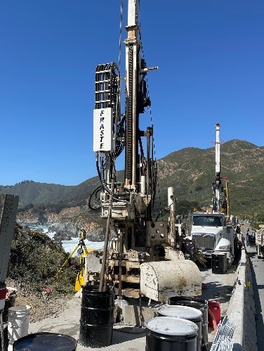
Drilling and casting of reinforced concrete columns will result in a series of full overnight closures of Hwy. 1 at Rocky Creek. Travelers can expect the following full overnight closures and intermittent daytime closures:
- Full overnight closures of Hwy. 1 at Rocky Creek will take place on Wednesday Oct. 9 and Thursday Oct. 10, from 10 pm to 6 am.
- The previously scheduled full overnight closure for Friday Oct. 11, has been cancelled and rescheduled. It will now take place on Thursday Oct. 17, from 10 pm to 6 am.
- For the week of October 13, daytime travelers can expect intermittent delays of up to 20 minutes as crews bring equipment on site for continued excavation work.
- Also, for the week of Oct. 13, there is the possibility of one additional overnight closure. An update will be provided when the schedule of this closure is confirmed.
Overnight Closures Needed for Construction of Support Columns
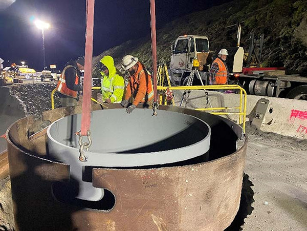
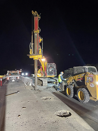
Crews are entering a critical phase of construction of the southbound section of the Rocky Creek viaduct. This viaduct is a bridge-like structure and during this next phase reinforced concrete support columns will be cast to support the weight of the structure.
Because this phase of construction involves drilling and concrete work in open holes, it is necessary for crews to maximize the number of consecutive shifts with full overnight closures so that the integrity of the bored holes is preserved. Working on an uninterrupted schedule also allows for this phase to be completed in advance of wet weather, reducing the chance for water intrusion and delays to the project schedule.
Daytime travelers will continue to enjoy access through the repair site driving on the northbound lane and directed by a temporary signal system.
Once construction of the southbound section of the Rocky Creek viaduct is complete, travel will be directed onto this southbound section and work will begin on construction of the northbound portion of the viaduct.
The estimate for completion of the Rocky Creek viaduct is summer 2025 and is dependent on conditions encountered during construction. The contractor for this project is Gordon N. Ball, Inc. of Alamo, CA.
Highway 1 remains closed 40 miles south of Carmel due to the Regent’s Slide. However, the vast majority of the Big Sur coast remains accessible and open.
UPDATE #12 (10/3/2024)
UPCOMING REPAIR SCHEDULE ON HIGHWAY 1 AT ROCKY CREEK
TO INCLUDE FULL OVERNIGHT CLOSURES
MONTEREY COUNTY – Caltrans will continue with emergency repairs to Highway 1 near the Rocky Creek Bridge, 12 miles south of Carmel. Caltrans previously stabilized and reinforced Highway 1 at this location after a March 30 slipout resulted in a loss of a section of the southbound lane.
Upcoming Repair Schedule
Drilling and casting of reinforced concrete columns will result in a series of full overnight closures of Hwy. 1 at Rocky Creek. Travelers can expect the following full and intermittent closures:
- For Thursday Oct. 3, there will be a full overnight closure of Hwy. 1 at Rocky Creek from 10 pm to 6 am.
- There are no closures scheduled on Friday Oct. 4 and Saturday Oct. 5.
- Five consecutive full overnight closures are confirmed from Sunday Oct. 6 thru Thursday Oct. 10, from 10 pm to 6 am.
- A full closure of Highway 1 at Rocky Creek will take place on Friday October 11, from 11:30 pm to 5:30 am, to allow for a crane to deploy equipment on site.
Updates will be provided regarding any travel impacts for the week of Oct. 13.
Overnight Closures Needed for Construction of Support Columns
Crews are entering a critical phase of construction of the southbound section of the Rocky Creek viaduct. This viaduct is a bridge-like structure and during this next phase reinforced concrete support columns will be cast to support the weight of the structure.
Because this phase of construction involves drilling and concrete work in open holes, it is necessary for crews to maximize the number of consecutive shifts with full overnight closures so that the integrity of the bored holes is preserved. Working on an uninterrupted schedule also allows for this phase to be completed in advance of wet weather, reducing the chance for water intrusion and delays to the project schedule.
Daytime travelers will continue to enjoy access through the repair site driving on the northbound lane and directed by a temporary signal system.
Once construction of the southbound section of the Rocky Creek viaduct is complete, travel will be directed onto this southbound section and work will begin on construction of the northbound portion of the viaduct.
The estimate for completion of the Rocky Creek viaduct is summer 2025 and is dependent on conditions encountered during construction. The contractor for this project is Gordon N. Ball, Inc. of Alamo, CA.
Highway 1 remains closed 40 miles south of Carmel due to the Regent’s Slide. However, the vast majority of the Big Sur coast remains accessible and open.
UPDATE #2 (9/30/2024)
CONTINUED CRACKING AND LAND MOVEMENT AT REGENT'S SLIDE WILL DELAY REOPENING OF HIGHWAY 1
Nearly 100 Miles of Big Sur Coast Remain Accessible and Open
MONTEREY COUNTY – Caltrans announced today that due to continued cracking occurring at the repair site, a portion of previously damaged roadway located on Highway 1 at Regent’s Slide will not reopen in 2024. Updates on an estimated reopening date and the progress of repairs will be provided on a regular basis.
On August 16, Caltrans announced that repair work at Regent’s Slide would pause after crews discovered new surface cracks in the slope where major excavation efforts were underway. In the weeks since that update, continued land movement and slope cracking were observed during intensive project monitoring and investigation.
Before excavation work begins again, crews still need to monitor both the new slide and the area of undisturbed land above the project site where the start of new excavation work is planned. Data from these investigations will inform the repair design and major excavation work. Repairs will resume when crews and equipment can be positioned on stable ground above and behind the new slide activity.
This approach emphasizes Caltrans’ commitment to address challenging repairs using methods that prioritize crew safety while working diligently to open the roadway as soon as possible.
The Big Sur Coast Remains Accessible and Open
Over 100 miles of Highway 1 between Cambria and Carmel remain open with the exception of a 6.8-mile segment from one mile south of the Esalen Institute to two miles north of the community of Lucia.
For travelers from Northern California, the incredible historic bridges, waterfalls, restaurants, and lodging amenities of the Big Sur coast all remain accessible.
Kirk Gafill, president of the Big Sur Chamber of Commerce said, “Caltrans emergency repairs to Highway 1 at Rocky Creek earlier this year have provided visitors with direct access to the unique landscapes in and around Big Sur. We look forward to the safe and timely completion of repairs at Regent's Slide that will allow for the full reopening of Highway 1 between Big Sur and Cambria."
Travelers from Southern California will find unparalleled views and charming destinations along Highway 1 when they visit the communities of Lucia, Gorda, Ragged Point, San Simeon, and Cambria.
Jim Ramey of the Ragged Point Inn said, “Since the 1960s, my family has been privileged to share the beauty and magic of the south Big Sur coast with visitors from around the world. Today, visitors from the south still have clear access to magnificent views, hiking, camping, beaches, restaurants, resorts, and all the sights that make this area distinctive. Caltrans has always responded as quickly as possible to road events and closures, and we eagerly await full access to the north.”
Updates on an estimated reopening date and the progress of repairs at Regent’s Slide will be provided on a regular basis.
Road information and updates can also be found on Caltrans District 5 Social Media platforms: X/Twitter at: @CaltransD5, Facebook at: Caltrans Central Coast (District 5) and Instagram at: Caltrans_D5.
UPDATE #11 (9/25/2024)
UPCOMING REPAIR SCHEDULE ON HIGHWAY 1 AT ROCKY CREEK
TO INCLUDE FULL OVERNIGHT CLOSURES
MONTEREY COUNTY – Caltrans will continue with emergency repairs to Highway 1 near the Rocky Creek Bridge, 12 miles south of Carmel. Caltrans previously stabilized and reinforced Highway 1 at this location after a March 30 slipout resulted in a loss of a section of the southbound lane.
Upcoming Repair Schedule
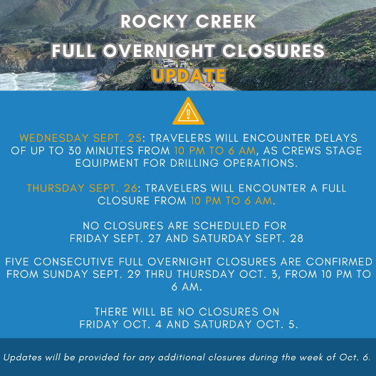
Drilling and casting of reinforced concrete columns will result in a series of full overnight closures of Hwy. 1 at Rocky Creek. All overnight closures will take place between 10 pm and 6 am.
- For today, Wednesday Sept. 25, travelers will encounter delays of up to 30 minutes from 10 pm to 6 am, as crews stage equipment for drilling operations.
- For Thursday Sept. 26, travelers will encounter a full closure from 10 pm to 6 am.
- No closures are scheduled for Friday Sept. 27 and Saturday Sept. 28.
- Five consecutive full overnight closures are confirmed from Sunday Sept. 29 thru Thursday Oct. 3, from 10 pm to 6 am. There will be no closures scheduled on Friday Oct. 4 and Saturday Oct. 5.
- Lastly, from Monday Sept. 30 through Friday Oct. 4, during daytime hours, travelers may encounter intermittent delays of up to 15 minutes as a result of concrete operations.
Updates will be provided regarding any additional closures for the week of Oct. 6.
Overnight Closures Needed for Construction of Support Columns
Crews are entering a critical phase of construction of the southbound section of the Rocky Creek viaduct. This viaduct is a bridge-like structure and during this next phase reinforced concrete support columns will be cast to support the weight of the structure.
Because this phase of construction involves drilling and concrete work in open holes, it is necessary for crews to maximize the number of consecutive shifts with full overnight closures so that the integrity of the bored holes is preserved. Working on an uninterrupted schedule also allows for this phase to be completed in advance of wet weather, reducing the chance for water intrusion and delays to the project schedule.
Daytime travelers will continue to enjoy access through the repair site driving on the northbound lane and directed by a temporary signal system.
Once construction of the southbound section of the Rocky Creek viaduct is complete, travel will be directed onto this southbound section and work will begin on construction of the northbound portion of the viaduct.
The estimate for completion of the Rocky Creek viaduct is summer 2025 and is dependent on conditions encountered during construction. The contractor for this project is Gordon N. Ball, Inc. of Alamo, CA.
Highway 1 remains closed 40 miles south of Carmel due to the Regent’s Slide.
UPDATE #10 (9/17/2024)
CALTRANS MODIFIES PREVIOUSLY ANNOUNCED SCHEDULE FOR
OVERNIGHT CLOSURES OF HIGHWAY 1 AT ROCKY CREEK
MONTEREY COUNTY – Caltrans will continue with emergency repairs to Highway 1 near the Rocky Creek Bridge, 12 miles south of Carmel. Caltrans previously stabilized and reinforced Highway 1 at this location after a March 30 slipout resulted in a loss of a section of the southbound lane.
Repair Schedule Update
Caltrans has modified the previously announced overnight closure schedule on Hwy. 1 at Rocky Creek. All overnight closures will take place between 10 pm and 6 am.
For Wednesday Sept. 25, travelers will encounter delays of up to 30 minutes from 10 pm to 6 am, as crews stage equipment for drilling operations.
For Thursday Sept. 26, travelers will encounter a full closure from 10 pm to 6 am.
No closures are scheduled for Friday Sept. 27 and Saturday Sept. 28.
Five consecutive full overnight closures are confirmed from Sunday Sept. 29 thru Thursday Oct. 3, from 10 pm to 6 am. There will be no closures scheduled on Friday Oct. 4 and Saturday Oct. 5.
Updates will be provided regarding any additional closures for the week of Oct. 6.
Overnight Closures Needed for Construction of Support Columns
Crews are entering a critical phase of construction of the southbound section of the Rocky Creek viaduct. This viaduct is a bridge-like structure and during this next phase reinforced concrete support columns will be cast to support the weight of the structure.
Because this phase of construction involves drilling and concrete work in open holes, it is necessary for crews to maximize the number of consecutive shifts with full overnight closures so that the integrity of the bored holes is preserved. Working on an uninterrupted schedule also allows for this phase to be completed in advance of wet weather, reducing the chance for water intrusion and delays to the project schedule.
Daytime travelers will continue to enjoy access through the repair site driving on the northbound lane and directed by a temporary signal system.
Once construction of the southbound section of the Rocky Creek viaduct is complete, travel will be directed onto this southbound section and work will begin on construction of the northbound portion of the viaduct.
The estimate for completion of the Rocky Creek viaduct is summer 2025 and is dependent on conditions encountered during construction. The contractor for this project is Gordon N. Ball, Inc. of Alamo, CA.
Highway 1 remains closed 40 miles south of Carmel due to the Regent’s Slide.
Road information and updates can also be found on Caltrans District 5 Social Media platforms: X/Twitter at: @CaltransD5, Facebook at: Caltrans Central Coast (District 5) and Instagram at: Caltrans_D5.
UPDATE #9 (9/16/2024)
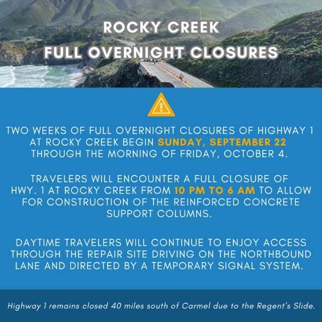
TWO WEEKS OF FULL OVERNIGHT CLOSURES OF HIGHWAY 1 AT ROCKY CREEK TO BEGIN SUNDAY SEPT. 22 AS CREWS BUILD SUPPORT COLUMNS
MONTEREY COUNTY – Caltrans will continue with emergency repairs to Highway 1 near the Rocky Creek Bridge, 12 miles south of Carmel. Caltrans previously stabilized and reinforced Highway 1 at this location after a March 30 slipout resulted in a loss of a section of the southbound lane.
Overnight Closures Needed for Construction of Support Columns
Crews are entering a critical phase of construction of the southbound section of the Rocky Creek viaduct. This viaduct is a bridge-like structure and during this next phase reinforced concrete support columns will be cast to support the weight of the structure.
Because this phase of construction involves drilling and concrete work in open holes, it is necessary for crews to work consecutive shifts with full overnight closures so that the integrity of the bored holes is preserved. Working on an uninterrupted schedule also allows for this phase to be completed in advance of wet weather, reducing the chance for water intrusion and delays to the project schedule.
Upcoming Repair Schedule Update
This upcoming phase of construction involves an exception to the customary overnight work schedule and includes full overnight closures on a weekend.
Beginning Sunday September 22, and continuing through the morning of Friday October 4, travelers will encounter a full closure of Hwy. 1 at Rocky Creek from 10 pm to 6 am, to allow for construction of the reinforced concrete support columns.
Daytime travelers will continue to enjoy access through the repair site driving on the northbound lane and directed by a temporary signal system.
Once construction of the southbound section of the Rocky Creek viaduct is complete, travel will be directed onto this southbound section and work will begin on construction of the northbound portion of the viaduct.
The estimate for completion of the Rocky Creek viaduct is summer 2025 and is dependent on conditions encountered during construction. The contractor for this project is Gordon N. Ball, Inc. of Alamo, CA.
Highway 1 remains closed 40 miles south of Carmel due to the Regent’s Slide.
Road information and updates can also be found on Caltrans District 5 Social Media platforms: X/Twitter at: @CaltransD5, Facebook at: Caltrans Central Coast (District 5) and Instagram at: Caltrans_D5.
Our crews deserve to get home safely too.
Drive slowly and carefully in work zones.
UPDATE #8 (9/6/2024)
INTERMITTENT DAYTIME DELAYS CONTINUE ON HIGHWAY 1 AT ROCKY CREEK
FOR WEEK OF SEPTEMBER 8
MONTEREY COUNTY - Caltrans will continue with emergency repairs to Highway 1 near the Rocky Creek Bridge, 12 miles south of Carmel. Caltrans previously stabilized and reinforced Highway 1 at this location after a March 30 slipout resulted in a loss of a section of the southbound lane.
Upcoming Repair Schedule Update
For the week of Sunday September 8, daytime traffic control, customarily directed by a temporary signal, will be replaced with flagging crews from Monday September 9, thru Thursday September 12. These flagging operations are necessary to allow for the movement of trucks to deliver equipment and materials for crews as they prepare for the next phase of construction efforts. Daytime flagging will be intermittent and on an as needed basis so that construction vehicles can move in and out of the work area situated behind concrete barriers. Travelers can expect intermittent daytime delays of up to a maximum of 20 minutes.
There will be no overnight closures or delays the week of Sunday September 8, and travelers overnight will continue to enjoy access through the repair site driving on the northbound lane and directed by a temporary signal system. All Big Sur businesses and amenities remain open and accessible.
Customary Overnight Repair Schedule
Overnight work will customarily take place five nights a week, Sunday through Thursday night, and scheduled from 10 pm to 6 am. No overnight work will take place on Friday or Saturday nights.
The estimate for completion of the Rocky Creek viaduct is summer 2025 and is dependent on conditions encountered during construction. The contractor for this project is Gordon N. Ball, Inc. of Alamo, CA.
Highway 1 remains closed 40 miles south of Carmel due to the Regent's Slide.
Road information and updates can also be found on Caltrans District 5 Social Media platforms: X/Twitter at: @CaltransD5, Facebook at: Caltrans Central Coast (District 5) and Instagram at: Caltrans_D5.
UPDATE #7 (8/30/2024)
INTERMITTENT DAYTIME DELAYS ON HIGHWAY 1 AT ROCKY CREEK
FOR WEEK OF SEPTEMBER 1
MONTEREY COUNTY - Caltrans will continue with emergency repairs to Highway 1 near the Rocky Creek Bridge, 12 miles south of Carmel. Caltrans previously stabilized and reinforced Highway 1 at this location after a March 30 slipout resulted in a loss of a section of the southbound lane.
Upcoming Repair Schedule Update
For the week of Sunday September 1, daytime traffic control, customarily directed by a temporary signal, will be replaced with flagging crews from Tuesday September 3, thru Saturday September 6. These flagging operations are necessary to allow for the movement of trucks delivering equipment and materials for crews as they prepare for the next phase of construction efforts. Daytime flagging will be intermittent and on an as needed basis so that construction vehicles can move in and out of the work area situated behind concrete barriers. Travelers can expect intermittent daytime delays of 5 to 10 minutes.
There will be no overnight closures or delays the week of Sunday September 1, and travelers overnight will continue to enjoy access through the repair site driving on the northbound lane and directed by a temporary signal system. All Big Sur businesses and amenities remain open and accessible.
Customary Overnight Repair Schedule
Overnight work will customarily take place five nights a week, Sunday through Thursday night, and scheduled from 10 pm to 6 am. No overnight work will take place on Friday or Saturday nights.
The estimate for completion of the Rocky Creek viaduct is summer 2025 and is dependent on conditions encountered during construction. The contractor for this project is Gordon N. Ball, Inc. of Alamo, CA.
UPDATE #6 (8/24/2024)
NO OVERNIGHT CLOSURES ON HIGHWAY 1 AT ROCKY CREEK
FOR WEEK OF AUGUST 25 THROUGH LABOR DAY WEEKEND
MONTEREY COUNTY – Caltrans will continue with emergency repairs to Highway 1 near the Rocky Creek Bridge, 12 miles south of Carmel. Caltrans previously stabilized and reinforced Highway 1 at this location after a March 30 slipout resulted in a loss of a section of the southbound lane.
Upcoming Repair Schedule Update
For the week of Sunday August 25, with the recent completion of overnight drilling work for construction of a shoring wall near the center line, travelers will not encounter any overnight closures or overnight delays on Highway 1 at Rocky Creek, from Sunday August 25 through the upcoming Labor Day Weekend.
Daytime repair work will take place in the Rocky Creek project area behind concrete barriers known as K-rail and should not result in any significant travel delays. Daytime travelers will continue to enjoy access through the repair site driving on the northbound lane and directed by a temporary signal system. All Big Sur businesses and amenities are open.
Customary Overnight Repair Schedule
Overnight work will customarily take place five nights a week, Sunday through Thursday night, and scheduled from 10 pm to 6 am. No overnight work will take place on Friday or Saturday nights.
The estimate for completion of the Rocky Creek viaduct is summer 2025 and is dependent on conditions encountered during construction. The contractor for this project is Gordon N. Ball, Inc. of Alamo, CA.
Highway 1 remains closed 40 miles south of Carmel due to the Regent’s Slide.
8/16/2024
CALTRANS HALTS EXCAVATION WORK AT REGENT'S SLIDE ON HIGHWAY 1 DUE TO SLIDE ACTIVITY
Much of Highway 1 along the Big Sur coast remains accessible and open
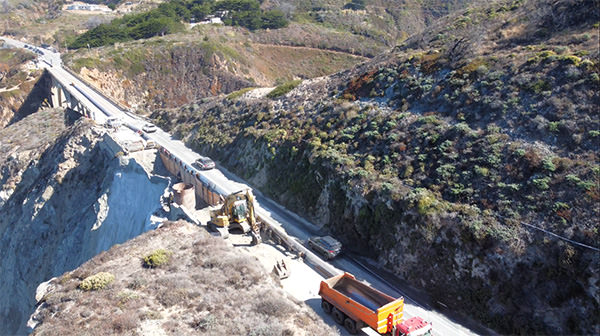
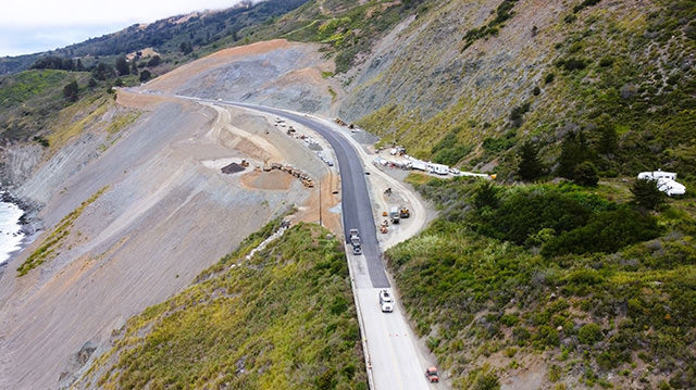
MONTEREY COUNTY - Caltrans today announced that it has temporarily halted excavation work on Highway 1 at Regent's Slide due to continuing slide activity in and around the repair site. While much of Highway 1 along the Big Sur coast remains accessible and open, Caltrans engineers are now assessing the slide area and gathering data to keep the public informed of the new timeline for reopening.
While excavating the slope with bulldozers earlier this month, crews noticed surface cracking at several points around the area being excavated, indicating additional slide activity. Caltrans mapped this cracking and determined that this new slide would likely continue to move and impact the ongoing work to reopen the roadway. For the safety of work crews, Caltrans halted excavation work.
Highway 1 at Regent's Slide has been closed since February 9, 2024, due to a slide that originated 450 feet above the roadway. The slide displaced material that engulfed the roadway and continued down to the beach and ocean below. While Caltrans has made progress toward reopening the roadway, repair efforts have been challenged by the height and steepness of the slope, which have required flexibility and frequent adjustments to repair strategies to ensure the safety of workers on site.
Although through travel on Highway 1 from Carmel to Cambria is not possible at this time, travel to the communities of Cambria, San Simeon, and all the amenities of the south coast continue to be within reach from Southern California, as do businesses and attractions on the coast south of the Monterey/Carmel area coming from Northern California.
Earlier this week, Caltrans installed three sensors where surface cracking was observed. Caltrans will collect data from these sensors over the next several weeks to determine the magnitude, rate, direction, depth, and type of movement involved. Engineers will evaluate data to determine if additional stabilization work is needed. Excavation work will resume once Caltrans confirms it is safe to do so.
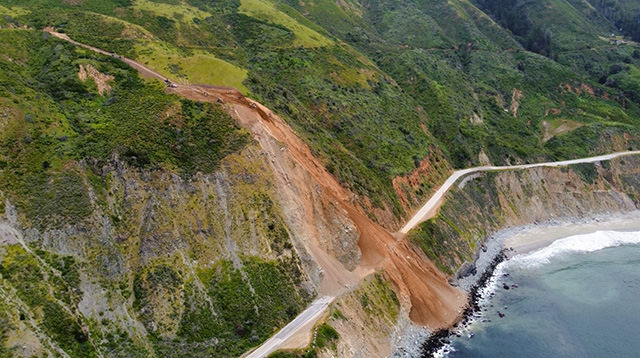
A 6.8-mile segment of Highway 1 will remain closed while repairs continue. Regent's Slide is located 45 miles south of Carmel at Post Mile (PM) 27.8. The southern turnaround point on Highway 1 is at PM 25.3, two miles north of Lucia. The northern turnaround point is located at Lime Creek at PM 32.1, just south of the Esalen Institute.
Aerial view of Regent's Slide on Highway 1, August 7, 2024.
8/16/2024
ROCK SLOPE PROTECTION PROJECT ON HIGHWAY 1 NEAR FERNWOOD
TO BEGIN MONDAY AUGUST 19 WITH TRAFFIC CONTROL
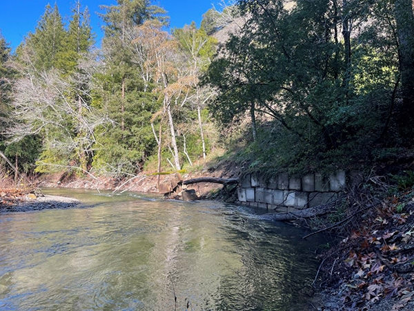
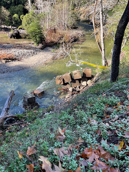
MONTEREY COUNTY - A rock slope protection project below Highway 1 near the community of Fernwood is scheduled to begin Monday August 19.
Crews will armor the bank of the river with four to six ton rocks which will make the slope capable of withstanding the erosive forces of the Big Sur River and protect the integrity of the roadway above.
Starting on Monday August 19, one-way traffic control, directed by flagging crews, will be in effect seven days a week, from 7 am to 6 pm. The location of the project is on Highway 1 at Post Mile 47.8 and approximately .75 miles north of the community of Fernwood.
During previous winter storms, several concrete blocks which previously armored the highway were loosened by rains and high-water flows in the Big Sur River.
This project is scheduled to be complete at the end of October 2024.
The contractor for this $7.5 million project is Graniterock Construction of Watsonville, CA.
UPDATE #5 (8/15/2024)
FULL OVERNIGHT CLOSURES ON HIGHWAY 1 AT ROCKY CREEK
RETURN FOR WEEK OF AUGUST 18
MONTEREY COUNTY - Caltrans will continue with emergency repairs to Highway 1 near the Rocky Creek Bridge, 12 miles south of Carmel. Caltrans previously stabilized and reinforced Highway 1 at this location after a March 30 slipout resulted in a loss of a section of the southbound lane.
Upcoming Repair Schedule Update
For the week of Sunday August 18, travelers will encounter a full overnight closure of Highway 1 at Rocky Creek for five nights, from Sunday August 18 through Thursday August 22, from 10 pm to 6 am.
For the week of Sunday August 25, no overnight closures are scheduled. Further updates will be provided if there are changes to this schedule.
Daytime repair work will take place in the Rocky Creek project area behind concrete barriers known as K-rail and should not result in any significant travel delays. Daytime travelers will continue to enjoy access through the repair site driving on the northbound lane and directed by a temporary signal system. All Big Sur businesses and amenities are open.
Customary Overnight Repair Schedule
Overnight work will customarily take place five nights a week, Sunday through Thursday night, and scheduled from 10 pm to 6 am. No overnight work will take place on Friday or Saturday nights.
The estimate for completion of the Rocky Creek viaduct is summer 2025 and is dependent on conditions encountered during construction. The contractor for this project is Gordon N. Ball, Inc. of Alamo, CA.
Highway 1 remains closed 40 miles south of Carmel due to the Regent's Slide.

UPDATE #3 (8/2/2024)
OVERNIGHT REPAIR WORK ON HIGHWAY 1 AT ROCKY CREEK
CONTINUES WEEK OF AUGUST 11
MONTEREY COUNTY - Caltrans will continue with emergency repairs to Highway 1 near the Rocky Creek Bridge, 12 miles south of Carmel. Caltrans previously stabilized and reinforced Highway 1 at this location after a March 30 slipout resulted in a loss of a section of the southbound lane.
Upcoming Repair Schedule Update
For the week of Sunday August 4, travelers will encounter a full overnight closure of Highway 1 at Rocky Creek for five nights, from Sunday August 4 through Thursday August 8, from 10 pm to 6 am.
For the week of Sunday August 11, travelers will encounter a full overnight closure of Highway 1 at Rocky Creek for five nights, from Sunday August 11 through Thursday August 15, from 10 pm to 6 am. Further updates will be provided if there is a change to this schedule.
Daytime repair work will take place in the Rocky Creek project area behind concrete barriers known as K-rail and should not result in any significant travel delays. Daytime travelers will continue to enjoy access through the repair site driving on the northbound lane and directed by a temporary signal system. All Big Sur businesses are open.
Overnight work will be scheduled five nights a week, Sunday through Thursday night, on a consistent schedule from 10 pm to 6 am. No overnight work will take place on Friday or Saturday nights.
There will be two types of traffic impacts associated with overnight work. These will involve either intermittent delays of up to one-hour or full overnight closures of the highway.
When repair work involves the occasional movement of equipment and machinery across the entire width of the project area, this will result in intermittent delays of up to one hour, Sunday through Thursday nights form 10 pm to 6 am. These intermittent one-hour delays for overnight work will be a recurring feature of the Rocky Creek repair work.
When equipment and machinery are required to work across the full width of the project area throughout the entire overnight shift, this will result in a full closure of the highway, Sunday through Thursday nights form 10 pm to 6 am. No travel will be permitted through the repair site during full overnight closures.
The estimate for completion of the Rocky Creek viaduct is summer 2025 and is dependent on conditions encountered during construction. The contractor for this project is Gordon N. Ball, Inc. of Alamo, CA.
Highway 1 remains closed 40 miles south of Carmel due to the Regent's Slide which is expected to be cleared by late fall of this year.
OVERNIGHT CLOSURES ON HIGHWAY 1 AT ROCKY CREEK NORTH OF BIG SUR TO BEGIN MONDAY JULY 22
MONTEREY COUNTY – Caltrans announced today that it will move to the next phase of emergency repairs to Highway 1 south of the Rocky Creek Bridge starting Monday, July 22, which will include partial and full overnight closures.
Caltrans stabilized and reinforced Highway 1 at this location after a March 30 slipout resulted in a loss of part of the southbound lane. Since May 17, travelers have had 24/7 access through the repair site using the northbound lane by means of a temporary signal system.
From Monday, July 22, to Thursday, July 25, travelers will encounter partial overnight closures of Highway 1 at Rocky Creek between 9 p.m. and 6 a.m. with delays of up to one hour. Crews will use these partial closures to reposition the existing K-rail and place temporary striping to allow for construction activities in the southbound lane.
Full overnight closures of Highway 1 at Rocky Creek will also be necessary intermittently for the remaining repair work and will be scheduled when equipment needs to be deployed across the entire roadway. Unlike the partial closures, no travel through the work zone will be permitted during the full overnight closures.
The first of five consecutive full overnight closure will begin Sunday, July 28:
Sunday, July 28 at 10 p.m. to Monday, July 29 at 6 a.m.
Monday, July 29 at 9 p.m. to Tuesday, July 30 at 6 a.m.
Tuesday, July 30 at 9 p.m. to Wednesday, July 31 at 6 a.m.
Wednesday, July 31 at 9 p.m. to Thursday, August 1 at 6 a.m.
Thursday, August 1 at 9 p.m. to Friday, August 2 at 6 a.m.
There will be no overnight work scheduled on Friday or Saturday nights.
Caltrans expects to complete repairs at Rocky Creek in summer 2025, and that estimate is dependent on conditions encountered during construction.
Regular updates will be provided to keep the public informed about the construction schedule.
The contractor for this project is Gordon N. Ball, Inc. of Alamo.
UPDATE #8 (6/20/2024)
HIGHWAY 1 AT PAUL'S SLIDE TO REOPEN SUNDAY, JUNE 23
MONTEREY COUNTY - Owing to favorable site conditions and recent construction progress, Caltrans will reopen Highway 1 at Paul's Slide on Sunday, June 23. The completion of major construction activities will open direct access to the community of Lucia, the Camaldoli Hermitage, and residents living within the newly reopened 4.3 miles of highway.
Direct access on Highway 1 through Paul's Slide has not been possible since a major slide on January 14, 2023, displaced an estimated 500,000 cubic yards of material across the roadway.
"The challenge at Paul's Slide has always been to repair Highway 1 while movement continues within the slide location," said Caltrans Director Tony Tavares. "The completion of repairs and the reopening of a 4.3-mile section of this scenic byway will begin to restore some normalcy for business owners and residents in the area. We thank the local community for their patience and support. We also want to express appreciation for the persistence, ingenuity, and resolve demonstrated by Caltrans personnel and contracted crews throughout this process."
With the reopening of Paul's Slide, a 6.8-mile segment of Highway 1 will continue to remain closed due to ongoing repairs at Regent's Slide at Post Mile (PM) 27.8. Caltrans estimates it will complete repairs at Regent's Slide in late fall, which will open Highway 1 to direct travel along the entire run of the Big Sur coast between Cambria and Carmel.
With the reopening of Paul's Slide, the southern turnaround point on Highway 1, currently in place at Limekiln State Park at PM 21, will move north to PM 25.3, just south of the Vicente Creek Bridge. The turnaround location offers travelers both a clear line of sight on approach and ample space for large vehicles to maneuver in and turn around.
The northern turnaround point on Highway 1 will remain at Lime Creek at PM 32.1, just south of the Esalen Institute and will remain there until Caltrans completes repairs at Regent's Slide.
After the reopening at Paul's Slide, crews will be on site over the next several weeks to remove additional slide material, complete drainage installation, and implement erosion control measures. Travelers will encounter intermittent traffic control with only minimal delays during this work.
The contractor for repairs at Paul's Slide is Papich Construction of Arroyo Grande. The total cost of this project is approximately $60 million.
Road information and updates can also be found on Caltrans District 5 Social Media platforms: Twitter at: @CaltransD5, Facebook at: Caltrans Central Coast (District 5) and Instagram at: Caltrans_D5.
Caltrans will reopen Highway 1 at Paul's Slide on Sunday, June 23.
###
UPDATE #7 (5/31/2024)
HIGHWAY 1 AT PAUL'S SLIDE NOW EXPECTED TO REOPEN EARLY TO MID-JULY
MONTEREY COUNTY - Highway 1 at Paul's Slide, closed since January 14, 2023, when an estimated 500,000 cubic yards of material was displaced and engulfed the roadway, is now expected to reopen by early to mid-July. The southern closure of Highway 1, currently in place at Limekiln State Park, will move north and open direct access to the community of Lucia, the Camaldoli Hermitage, and area residents.
Paul's Slide (Post Mile 22) has been a known active slide area for much of the history of Highway 1 on the Big Sur coast. Continued movement of the mountain at various locations within the repair zone proved a challenge during construction and will continue to be a background dynamic of the reopened highway.
In part to address slide activity at this location, the roadway has been moved slightly inland and elevated at its south end. The repair will feature an expanded catchment area between the travel lanes and the slope. A concrete protective barrier and fencing will also extend along the northbound shoulder.
Crews are installing the last of three culverts which will convey water and debris below the roadway. Crews are also installing base material prior to final paving. In coming weeks crews will install guardrail, protective barriers, and place final striping in advance of the estimated early to mid-July reopening.
Completion Estimates for Other Slide Repairs
Dolan Point (Post Mile 29.5) Activated March 8, 2024
Repairs at the Dolan Point Slide are expected to be completed by early summer. Completion of repairs at Dolan Point will not result in an adjustment to the northern turnaround point at Lime Creek.
Regent's Slide (Post Mile 27.8) Activated March 9, 2024
The last of the repairs to be completed will be at Regent's Slide. Due to challenging conditions associated with the extreme slope at the site, repairs at Regent's Slide are now estimated to be completed in late fall. Completion of repairs at Regent's Slide would open up Highway 1 to direct travel between Cambria and Carmel.
Bicyclists are not permitted through construction zones at the Dolan Point Slide or Regent's Slide but are permitted to pass during regular convoy times at Paul's Slide. Please note that Regent's Slide is active, extremely steep, and the material across the road is unstable. There is absolutely no bicycle or pedestrian access on Highway 1 through Regent's Slide.
Except for an 11-mile section where repairs continue, travelers from the Cambria / San Simeon area are able to travel north as far as Limekiln State Park. Travelers from the Monterey / Carmel area are able to travel as far as Lime Creek, south of the Esalen Institute.
Road information and updates can also be found on Caltrans District 5 Social Media platforms: Twitter at: @CaltransD5, Facebook at: Caltrans Central Coast (District 5) and Instagram at: Caltrans_D5.
Repairs to Highway 1 at Paul's Slide.
###
UPDATE #6 (5/24/2024)
HIGHWAY 1 SLIDE REPAIRS MAKE PROGRESS WITH FULL OPENING BETWEEN CAMBRIA AND CARMEL ESTIMATED FOR LATE FALL
MONTEREY COUNTY - With the exception of an 11-mile section where repairs continue seven days a week at three major slides, the remainder of Highway 1 on the Big Sur coast is open to unrestricted public access.
Although direct travel between Carmel and Cambria is still not possible due to these repairs, the traveling public is welcome to take advantage of all the features of the Big Sur coast. Travelers from the Cambria / San Simeon area are able to travel north as far as Limekiln State Park. Travelers from the Monterey / Carmel area are able to travel as far as Lime Creek, south of the Esalen Institute.
Completion Estimates for Slide Repairs
Repairs at the Dolan Point Slide are expected to be completed by early summer. Completion of repairs at Dolan Point will not result in an adjustment to the turnaround point at Lime Creek.
Repairs at Paul's Slide are expected to be completed by late summer. At that point the current turnaround at Limekiln State Park will move north and provide direct access to the Camaldoli Hermitage and the community of Lucia.
The last of the repairs to be completed will be at Regent's Slide. Due to challenging conditions associated with the extreme slope at the site, repairs at Regent's Slide are now estimated to be completed in late fall. Completion of repairs at Regent's Slide will open up Highway 1 to direct travel between Cambria and Carmel.
Progress at Repair Sites
Dolan Point (Post Mile 29.5) Activated March 8, 2024
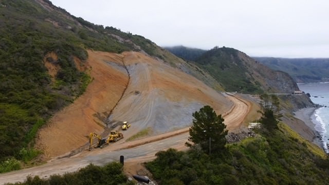
After a top-down removal of slide material and reduction of rocks by blasting crews, double twist cable mesh has been installed along the face of the slope. Crews are working to connect the seams of dozens of 150-foot lengths of mesh which were lifted into place by helicopter. This mesh will add an additional layer of protection to the highway below the slope.
Paul's Slide (Post Mile 22) Activated January 14, 2023
Crews have started installation of four major culverts at the site, completed final surveys for the new alignment of the roadway, and begun to install base material at the northern section of the repair. Crews continue to monitor and address slide activity above the repairs.
Regent's Slide (Post Mile 27.8) Activated March 9, 2024
Crews began top-down removal of slide material on April 30. Crews are employing bulldozers at the top of the slide and smaller and more nimble machines called spider excavators to work material down the slope. Because of the severe slope even the spider excavators, which are designed to negotiate steep terrain, need to be tied to and anchored by the bulldozers above them.
Crews ceased work entirely for five days last week due to movement in the slope uphill of the repairs. Crews were able to resume debris removal work this week.
It is approximately 450 feet from the top of Regent's Slide to the roadway and the slide itself covers the roadway and extends to the shore of the ocean. Repairs at Regent's are complex and will at some point include reduction of rock material by blasting crews. The steep slope at this site means that repairs will continue with due deliberation and caution.
points. However, bicyclists and pedestrians are not permitted to cross through Regent's Slide. The slide is active, extremely steep, and the material across the road is unstable. There is no bicycle or pedestrian access on Highway 1 through Regent's Slide.
Road information and updates can also be found on Caltrans District 5 Social Media platforms: Twitter at: @CaltransD5, Facebook at: Caltrans Central Coast (District 5) and Instagram at: Caltrans_D5.
Regent's Slide Repairs, May 16, 2024
###
UPDATE (5/15/2024)
GOVERNOR NEWSOM ANNOUNCES THE REOPENING OF HIGHWAY 1, AHEAD OF SCHEDULE
FOR IMMEDIATE RELEASE:
Tuesday, May 14, 2024
Governor's Press Office: (916) 445-4571
WHAT YOU NEED TO KNOW: The Governor announced today that a portion of Highway 1, near Big Sur, which was severely damaged by recent storms, is set to reopen more than a week ahead of schedule this Friday, May 17.
BIG SUR - Governor Gavin Newsom today announced that Caltrans will open the portion of Highway 1 closed by the Rocky Creek slip-out to traffic, starting at 6:30 a.m. this Friday, May 17 - eight days sooner than previously expected.
WHAT GOVERNOR NEWSOM SAID: "Crews have been working day and night to quickly repair the damage to Highway 1 caused by recent storms, which has disrupted the lives of individuals living in and around Big Sur - limiting access to the area and hampering tourism. Thanks to the diligent efforts, traffic will resume eight days ahead of schedule - bringing relief and a sense of normalcy back to one of California's most iconic coastal communities."
This portion of Highway 1 will reopen with the use of a 24/7 signalized traffic control. This temporary signal will provide unrestricted public access with one-way alternating traffic in both the north and southbound directions.
"Highway 1 is the jewel of the California highway system and our crews have been working non-stop for the last month and a half so Californians can have unrestricted access to this iconic area of our state," said Caltrans Director Tony Tavares. "I thank Governor Newsom, Senator John Laird and our elected officials for their unwavering support, the residents and businesses for their patience and the crews for reopening the roadway as quickly and as safely as possible."
"We are deeply grateful to have Highway 1 open and functional an entire week ahead of schedule. I want to sincerely thank Caltrans and the people of Big Sur for their work, effort, and patience through this process," said State Senator John Laird (D-Santa Cruz). "This was a true team effort, including Governor Newsom and his staff, Caltrans executives and contractors, Assemblymember Dawn Addis, Sheriff Tina Nieto, the California Highway Patrol, Big Sur Fire, and leaders in and the community of Big Sur. Highway 1 is a vital lifeline for communities on the Central Coast, and so our ongoing task will be to ensure this route remains resilient and open."
On March 30, a rockslide below Highway 1 south of the Rocky Creek Bridge left the southbound lane partially undermined and impassable. Approximately 6 feet of the pavement and a portion of an unreinforced masonry retaining wall that supported the highway fell to the ocean about 170 feet below the road.
Governor Newsom surveys damage near the Rocky Creek Bridge earlier this month.
In order to stabilize the remaining southbound lane and preserve the northbound lane, crews drilled, installed and grouted 40 vertical and 75 sub-horizontal steel elements into the slope. The steel elements, or rock dowels, are covered by an application of shotcrete to protect the exposed rock slope. This work required Caltrans to close the roadway in both directions at Rocky Creek, aside from twice-daily convoys through the slip-out area.
Now that Caltrans has stabilized the southbound lane and preserved the northbound lane, the site will continue to be monitored and visually inspected. A project to construct a permanent repair to the highway at this location is currently in the design phase, with an estimated completion date of spring 2025.
Earlier this month, the Governor surveyed the work being done at the Highway 1 slip-out and announced state action by signing an emergency proclamation. This action will help secure an estimated $100 million in federal funding for repairs to multiple areas of the state impacted by the recent storms.
###
UPDATE #16 (5/2/2024)
CONVOYS ON HIGHWAY 1 THROUGH ROCKY CREEK OPEN TO PUBLIC
WITH SOUTHBOUND AFTERNOON RESTRICTIONS
MONTEREY COUNTY - Crews continue to make progress with edge stabilization work at the Highway 1 Rocky Creek slip out. Stabilization of the southbound lane will help safeguard and protect the still viable northbound lane which is accommodating twice daily convoys through the repair site.
Construction Update
This first phase of the stabilization involves drilling, installing, and grouting in vertical and horizontal steel elements to stabilize the edge of the slip out. This is followed by an application of reinforced shotcrete to the sheer face of the rock slope. A crane has been deployed which carries a crew basket over the edge of the roadway to perform the horizontal drilling. Crews have been scheduled to work both day and overnight shifts.
Upon completion of this repair, the grouted rock dowels with applied shotcrete facing will provide shear resistance along potential failure planes in the rock mass and ensure that the rockslide below the southbound lane does not advance.
This stabilization project is a temporary repair which will allow the resumption of unrestricted traffic flow through the area until a permanent fix can be designed and constructed that would restore the southbound lane that was lost in the rockslide.
Due to high winds in the area, crews have been unable to drill stabilizing horizontal rock dowels into the rock slope since the morning of Monday April 29. To date, 46 of a total of 75 horizontal rock dowels have been installed. Drilling of horizontal dowels is expected to be suspended through this Friday due to forecasted high winds.
During high wind events that halt emergency stabilization work, crews are still able to complete geotechnical subsurface investigations which will advance design of the permanent repair at the site.
Caltrans continues to estimate that the completion date for the initial stabilization work at the Rocky Creek slip out will be Memorial Day, May 27. This would mark the end of the current convoys and allow alternating one-way travel through the area without an escort using 24/7 signalized traffic control. In upcoming weeks this estimate will be updated as production rates on the repair come into better focus.
Convoys Update
There are twice-daily convoys on Highway 1 through the Rocky Creek slip out open to all members of the traveling public. The first convoy will run for approximately an hour beginning at 7 am, and the last convoy will run for approximately an hour beginning at 5 pm. Highway 1 through the Rocky Creek slip out will continue to be closed during the hours between convoys so that crews can continue the repair work to stay on schedule to reopen the roadway by Memorial Day.
Since convoys need time to alternate the travel direction during the one-hour window, travelers are advised to arrive as early as possible to enter the queue. A timely conclusion of the one-hour window is necessary to maintain the road repair schedule.
The public will have access in both directions during the morning convoy. In the afternoon, the public will be able to use the northbound convoy to leave the area. However, only local residents, essential workers, and members of the traveling public with existing travel reservations will be allowed to join the 5 pm southbound convoy. Travelers who go south to Big Sur at 5 pm will not be able to return north until the next day at 7 am. Highway 1 is closed to all traffic south of the Big Sur area.
Emergency medical response and other essential services may be delayed for those traveling south of Rocky Creek on Highway 1. Travelers who participate in convoys on Highway 1 through Rocky Creek, are advised of the inherent risks involved with entering the area.
Road information and updates can also be found on Caltrans District 5 Social Media platforms: X.com at: @CaltransD5, Facebook at: Caltrans Central Coast (District 5) and Instagram at: Caltrans_D5.
Our crews deserve to get home safely too.
Drive slowly and carefully in work zones.
CHP Traffic Incident Information Page: http://cad.chp.ca.gov
Traveler information at: https://quickmap.dot.ca.gov/
Crews perform geotechnical subsurface investigations at Rocky Creek which will advance design of the permanent repair at the site.
###
UPDATE #15 (4/28/2024)
CALTRANS EXTENDS ROCKY CREEK CONVOY TO THE PUBLIC
BEGINNING MONDAY, APRIL 29
MONTEREY COUNTY - Starting Monday, April 29, Caltrans will open the twice-daily convoys on Highway 1 through the Rocky Creek slip-out to all members of the traveling public. The convoys will run from 7 a.m. to 8 a.m. and 5 p.m. to 6 p.m. each day. Highway 1 will continue to be closed at Rocky Creek the remainder of the day so crews can continue the repair work to stay on schedule to reopen the roadway by Memorial Day.
The public will have access in both directions during the morning convoy. In the afternoon, the public will be able to use the northbound convoy to leave the area; however, only local residents, essential workers and drivers with existing travel reservations will be allowed to join the southbound convoy. There is no exit to the south.
Since convoys need time to alternate the travel direction during the one-hour window, travelers are advised to arrive as early as possible to take advantage. A timely conclusion of the one-hour windows is necessary to maintain the road repair schedule. Caltrans will assess convoy demand during the week to see if the duration or schedule needs to be adjusted. To this point, convoys had only been available to local residents and essential workers.
"Getting Big Sur working again has taken true partnership - from the Governor's exceptional effort with state agencies, to local businesses, residents, and first responders. And thank you to my colleague Assembly Member Dawn Addis, whose collaboration has been vital," said State Sen. John Laird (D-Santa Cruz). "We are deeply committed to re-opening Big Sur, and as your elected representatives, we will work tirelessly on this effort. The community has taken hit after hit with fires, floods, and road outages. A thoughtful re-opening of Highway 1 gets people back to work and keeps businesses open."
Since the March 30 slip-out on Highway 1 at Rocky Creek, crews have focused their efforts on stabilizing the edge of the roadway in the southbound lane. Crews are reinforcing the southbound lane as a means of protecting and safeguarding the still viable northbound lane.
Working both daytime and overnight shifts, crews are using a crane to carry a crew basket with drilling equipment over the edge of the roadway to drill stabilizing horizontal rock dowels into the surface below the roadway.
Once the roadway edge is stabilized, crews will install a temporary signal and open Highway 1 to unrestricted traffic under alternating one-way traffic control. Caltrans estimates to complete this work by May 27. This repair schedule may be impacted by excessive winds, rain events or any change in the construction site conditions.
Road information and updates can also be found on Caltrans District 5 Social Media platforms: X.com at: @CaltransD5, Facebook at: Caltrans Central Coast (District 5) and Instagram at: Caltrans_D5.
Our crews deserve to get home safely too.
Drive slowly and carefully in work zones.
CHP Traffic Incident Information Page: http://cad.chp.ca.gov
Traveler information at: https://quickmap.dot.ca.gov/
UPDATE #14 (4/23/2024)
SPECIAL EARLY MORNING CONVOY SCHEDULE AT ROCKY CREEK
SUNDAY APRIL 28 FOR BIG SUR MARATHON
MONTEREY COUNTY- Weather permitting, daily convoys on Highway 1 through the Rocky Creek slip out will continue on a schedule of 7 am and 5 pm, through Saturday April 27.
The day of the Big Sur Marathon, Sunday April 28, Highway 1 will be closed between the Rocky Creek Bridge and Rio Road in Carmel from 5 am to 1 pm, to allow race participants to safely run the modified marathon course.
On Sunday morning, April 28, the start time of the morning convoy at Rocky Creek will be moved up from 7 am to 4 am. This early morning convoy will allow vehicles to pass through from 4 am to 4:45 am. All vehicles must travel north of Rio Road or south of Rocky Creek by 5 am when the race closure goes into effect.
Convoys on Highway 1 through Rocky Creek will return to their regular schedule starting Sunday April 28 at 5 pm.
Crews continue to make progress with edge stabilization efforts at the Highway 1 Rocky Creek slip out with an estimated date for completion of this work still scheduled for May 27. This would mark the end of the current convoys and allow alternating one-way travel through the area without an escort using 24/7 signalized traffic control.
UPDATE #14 (4/17/2024)
ROCKY CREEK REPAIRS CONTINUE WITH HORIZONTAL SUPPORT DRILLING AND ADDITION OF OVERNIGHT SHIFTS
Crews continue to make progress with edge stabilization work at the Highway 1 Rocky Creek slip out.
This first phase of the stabilization effort involves drilling, installing, and grouting in steel elements to stabilize the edge of the slip out. Last week crews completed installation of the vertical rock dowels. This week crews drilled anchor supports for deployment of a crane which is now in place and will allow crews to begin the installation of the horizontal rock dowels. This will be followed by an application of shotcrete to the sheer face of the rock slope.
The horizontal dowels will be installed in 5 rows and after each row is complete, the face of the rock slope will be treated with reinforcing shotcrete. There is a 12-hour cure time before crews can begin drilling work on the next horizontal row.
The rock dowels provide shear resistance along potential failure planes in the rock mass, the grout provides cementation and connection of the dowels to the rock mass, and the shotcrete facing distributes load to the dowels and protects the rock slope from wind and rain erosion.
Crews have installed a light tower on an outcropping above and adjacent to the slip out and crews performing drilling for the horizontal rock dowels will work their first overnight shift tonight. The plan going forward is for crews to work two 12-hour shifts per day.
This stabilization project is a temporary repair which will allow the resumption of unrestricted traffic flow through the area until a permanent fix can be designed and constructed that would restore the southbound lanes that were lost in the rockslide.
Caltrans recently estimated that the completion date for the initial stabilization work at the Rocky Creek slip out would be Memorial Day, May 27. This would mark the end of the current convoys and allow alternating one-way travel through the area without an escort using 24/7 signalized traffic control.
The current convoys are operated at 7 am and 5 pm and are intended for the use of local residents and essential workers only. Limiting the volume of vehicles through the repair site is one strategy which is helping manage the risks associated with conditions at the rockslide and with emergency response.
Road information and updates can also be found on Caltrans District 5 Social Media platforms: Twitter at: @CaltransD5, Facebook at: Caltrans Central Coast (District 5) and Instagram at: Caltrans_D5.
Crews in a crane-suspended basket begin horizontal drilling to reinforce the slope below the roadway at the Highway 1 Rocky Creek slip out on April 17, 2024.
###
UPDATE #12 (4/13/2024)
ROCKY CREEK CONVOYS RESCHEDULED FOR SUNDAY APRIL 14
TO 12 NOON AND 5 PM DUE TO LINGERING RAIN
MONTEREY COUNTY- Daily convoys through the Rocky Creek slip out on Highway 1, regularly scheduled at 7 am and 5 pm, have been rescheduled for Sunday April 14, to 12 noon and 5 pm. This change in schedule is due to lingering wet weather forecasted to remain in the area Sunday morning.
It is anticipated that convoys at Rocky Creek will return on Monday April 14 to the regular schedule of 7 am and 5 pm. Crews on site at the Rocky Creek slip out have reported that the site has remained in good condition throughout this weekend's rain event.
The current convoys are intended for the use of local residents and essential workers only. Limiting the volume of vehicles through the repair site is one strategy which is helping manage the risks associated with conditions at the rockslide and with emergency response.
UPDATE #11 (4/12/2024)
CALTRANS ANTICIPATES HIGHWAY 1 STABILIZATION WORK AT ROCKY CREEK TO BE COMPLETED BY MEMORIAL DAY
This will mark the end of convoys, beginning of signalized traffic control
MONTEREY COUNTY - Caltrans today announced it anticipates completing the initial repair work to stabilize the edge of Highway 1 south of the Rocky Creek Bridge by Memorial Day, May 27. This would mark the end of the current convoys and allow alternating one-way traffic through the area without an escort using 24/7 signalized traffic control.
"We know how important Highway 1 is to the regional economy, especially during the summer, so we are working to reopen the roadway as quickly and safely as possible while at the same time making it more resilient to future extreme weather events," said Caltrans Director Tony Tavares.
Since the March 30 slip-out that temporarily closed the roadway, Caltrans has conducted geotechnical assessments, widened and improved drainage in the northbound shoulder area, placed concrete barriers along the centerline to channelize convoy passage, and hired a contractor to drill, install, and grout vertical rock dowels through the southbound lane pavement adjacent to the existing west edge of the roadway.
This will be followed by a longer phase of the work in which crews will drill, install, and grout horizontal rock dowels. Once the reinforcing dowels are in place, the repair design calls for crews to install reinforced shotcrete to the vertical face of the repair to help stabilize the roadway along the cliffside. The drainage improvements will also help the roadway better withstand extreme weather events, which are becoming more common in the area due to climate change.
The construction timeline is subject to change due to a number of factors, including wind and rain. Installation of the horizontal rock dowels requires a crane to hold a basket with crewmembers in it over the edge of the roadway. Winds cannot exceed 25 mph for these activities. The repair schedule may also be impacted by rain events and any change in site conditions.
Until Caltrans stabilizes Highway 1, it will continue using twice daily convoys to move only local residents and essential workers through the area. Limiting the volume of vehicles through the repair site helps to manage risks associated with conditions at the slip out and with emergency response. Once the roadway edge is stabilized, crews will install a temporary signal and open Highway 1 to unrestricted traffic under alternating one-way traffic control. One-way traffic control will continue until further roadway work is completed and the roadway has cleared safety inspections.
UPDATE #10 (4/11/2024)
HIGHWAY 1 CONVOYS AT ROCKY CREEK CANCELLED FOR SATURDAY APRIL 13 DUE TO FORECASTED RAIN
MONTEREY COUNTY- Daily convoys at 7 am and 5 pm through the Rocky Creek slip out on Highway 1 will be cancelled on Saturday April 13, due to forecasted rain. Convoys are expected to resume at 7 am on Sunday April 14.
This cancellation is based on location specific forecast from the National Weather Service.
The current convoys are intended for the use of local residents and essential workers only. Limiting the volume of vehicles through the repair site is one strategy which is helping manage the risks associated with conditions at the rockslide and with emergency response.
UPDATE #9 (4/9/2024)
CONVOY SCHEDULE TO CHANGE ON HIGHWAY 1 EFFECTIVE WEDNESDAY APRIL 9 THROUGH ROCKY CREEK REPAIR SITE
MONTEREY COUNTY- Daily convoys on Highway 1 through the Rocky Creek repair site, previously scheduled for 8 am and 4 pm, will move to a 7 am and 5 pm schedule starting Wednesday April 10. The new 7 am and 5 pm convoy hours were decided on after consultations with community stakeholders and in collaboration with the Monterey County Department of Emergency Management.
Convoys are intended for the use of local residents and essential workers only. Limiting the volume of vehicles through the repair site is one strategy which is helping manage the risks associated with conditions at the slip out and with emergency response.
Public safety personnel have been consistent in their support for limiting convoys to residents and essential workers. There are limited public safety resources staged south of the closure area. Additionally, emergency responses through the closure area are complicated by the presence of heavy machinery staged in the northbound lane which could take up to an hour to remove.
Caltrans is reviewing daily updates from the National Weather Service which is forecasting rain later this week. An update on any possible cancellation of convoys will be provided on Wednesday April 10.
UPDATE #8 (4/8/2024)
HIGHWAY 1 CONVOYS THROUGH ROCKY CREEK CONTINUE/MOBILIZATION BEGINS IN THE EFFORT TO STABILIZE THE HIGHWAY
MONTEREY COUNTY- The daily convoys on Highway 1 through the site of the Rocky Creek Slip Out will continue daily at 8 am and 4 pm following assessments by Caltrans engineers this weekend. These convoys are primarily intended for residents and essential employees. Convoys are expected to occur all this week due to favorable weather conditions.
Caltrans Engineers and contractor forces continue to monitor the site for any significant changes and the public will be advised of any modifications to this schedule.
The installation of K-Rail, crash cushions and temporary striping at the site was completed yesterday. Ongoing site preparations will continue today. The Contractor is scheduled to mobilize on Monday, April 8 with the drilling of vertical anchors in the southbound lane of Route 1 to begin on Tuesday, April 9.
The contractor is working with Caltrans through the weekend with the goal of having a schedule for the completion of the temporary roadway stabilization. Details of this operation, work hours and timetable will be announced when plans are finalized.
Updates on the status of the closure of Highway 1 at the Rocky Creek Bridge will be provided as more information becomes available.
UPDATE #7 (4/6/2024)
HIGHWAY 1 CONVOYS THROUGH ROCK CREEK RESUMED THIS MORNING
MONTEREY COUNTY- The daily convoys on Highway 1 through the site of the Rocky Creek Slip Out resumed this morning, Saturday, April 6 at 8 am and are scheduled again at 4 pm following positive assessments by Caltrans engineers early this morning. These convoys are primarily intended for residents and essential employees.
Caltrans Engineers and maintenance staff continue to monitor the site for any significant changes and the public will be advised of any modifications to this schedule.
Activities this week included the addition of gravel to the drainage ditch off the shoulder of the northbound lane to ensure proper drainage through the site. Work was also completed to pave over a gravel-filled ditch and part of the dirt shoulder of the northbound lane to gain extra room in the travel lane.
Caltrans is continuing to focus on repair strategies to stabilize the edge of the roadway with details of this operation, work hours and timetable to be announced when details are certain. Work activities to commence this weekend include the installation of barrier to protect highway workers and temporary re-striping to accommodate equipment expected to be mobilized to this area.
Updates on the status of the closure of Highway 1 at the Rocky Creek Bridge will be provided as more information becomes available.
UPDATE #6 (4/5/2024)
HIGHWAY 1 CONVOYS EXPECTED TO RESUME THIS WEEKEND PENDING FINAL ASSESSMENTS BY CALTRANS ENGINEERS
MONTEREY COUNTY- The daily convoys on Highway 1 through the site of the Rocky Creek Slip Out are expected to resume on Saturday, April 6 at 8 am and again at 4 pm pending final assessments by Caltrans engineers scheduled to take place early tomorrow morning.
Caltrans Engineers and maintenance staff continue to monitor the site for any significant changes and the public will be advised of any modifications to this schedule.
Activities this week included the addition of gravel to the drainage ditch off the shoulder of the northbound lane to ensure proper drainage through the site. Work was also completed to pave over a gravel-filled ditch and part of the dirt shoulder of the northbound lane to gain extra room in the travel lane.
Caltrans is continuing to focus on repair strategies to stabilize the edge of the roadway with details of this operation, work hours and timetable to be announced when details are certain. Work activities to commence this weekend include the installation of barrier to protect highway workers and temporary re-striping to accommodate equipment expected to be mobilized to this area.
Updates on the status of the closure of Highway 1 at the Rocky Creek Bridge will be provided as more information becomes available.
UPDATE #5 (4/3/2024)
HIGHWAY 1 CONVOYS CANCELLED THROUGH ROCKY CREEK
THURSDAY AND FRIDAY DUE TO FORECASTED RAIN
MONTEREY COUNTY- Travelers are reminded that due to rain in the forecast, daily convoy passage on Highway 1 will be cancelled for Thursday April 4, and Friday April 5, at the repair site south of the Rocky Creek Bridge.
Crews will be on site during all rain events to inspect for any changes in site conditions.
Convoys are expected to resume on Saturday April 6, at 8 am. Engineers will continue to monitor the site for any significant changes and the public will be advised of any modifications to this schedule.
During the 8 am convoy window today, crews counted 157 vehicles passing through in the northbound direction with 165 vehicles passing by in the southbound direction.
This week crews added gravel to the drainage ditch off the shoulder of the northbound lane to ensure that it is able to continue to provide drainage through the site. Crews were also able to place fabric down and pave over the gravel-filled ditch and part of the dirt shoulder of the northbound lane to gain extra room in the travel lane.
Crews are continuing to focus on strategies to stabilize the edge of the roadway and work will continue once the rain event passes.
Updates on the status of the closure of Highway 1 at the Rocky Creek Bridge will be provided as more information becomes available.
UPDATE #4 (4/2/2024)
HIGHWAY 1 CONVOYS THROUGH ROCKY CREEK CANCELLED
THURSDAY AND FRIDAY DUE TO FORECASTED RAIN
MONTEREY COUNTY– Due to rain in the forecast, daily convoy passage on Highway 1 will be cancelled for Thursday April 4, and Friday April 5, at the repair site south of the Rocky Creek Bridge.
Crews will be on site during all rain events to inspect for any changes in site conditions.
Convoys are expected to resume on Saturday April 6, at 8 am. Engineers will continue to monitor the site for any significant changes and the public will be advised of any modifications to this schedule.
Note: Convoy access is limited to residents and essential workers only. The reduction of vehicles through the repair site is part of risk management efforts. These convoys are intended for essential travel only.
Engineering and construction crews continue their assessments of the slip out. In the coming days crews will place concrete barriers along 500 feet of the centerline of the roadway. Crews are focusing on strategies for stabilizing the edge of the roadway.
Updates on the status of the closure of Highway 1 at the Rocky Creek Bridge will be provided as more information becomes available.
Road information and updates can also be found on Caltrans District 5 Social Media platforms: Twitter at: @CaltransD5, Facebook at: Caltrans Central Coast (District 5) and Instagram at: Caltrans_D5.
UPDATE #3 (4/1/2024)
CREWS CONTINUE TO ASSESS HIGHWAY 1 SLIPOUT NEAR ROCKY CREEK
FORECASTED RAIN MAY LEAD TO CANCELLATION OF CONVOYS
MONTEREY COUNTY - Caltrans engineers continue to assess a slip out of the roadway on Highway 1 just south of the Rocky Creek Bridge. The initial slip out and closure of the road took place on the afternoon of Saturday March 30.
Crews are continuing to gather information at the site which will inform next steps to stabilize the edge of the roadway and design a permanent repair. In the next several days crews will place 500 feet of concrete barriers along the centerline of the roadway. This will help define a channel for convoy vehicles to pass through and will provide protection for workers working on repairs.
Convoys are scheduled in the north and southbound directions through the repair site at 8 am and 4 pm daily. These convoys are operating under close supervision by engineers at the site. As announced earlier, convoys will be cancelled due to any observed change in site conditions and due to wet weather.
The forecast or the Big Sur coast calls for possible rain in the coming days. An update will be provided should there be a need to cancel convoys later this week.
Updates on the status of the closure of Highway 1 at the Rocky Creek Bridge will be provided as more information becomes available.
Road information and updates can also be found on Caltrans District 5 Social Media platforms: Twitter at: @CaltransD5, Facebook at: Caltrans Central Coast (District 5) and Instagram at: Caltrans_D5.
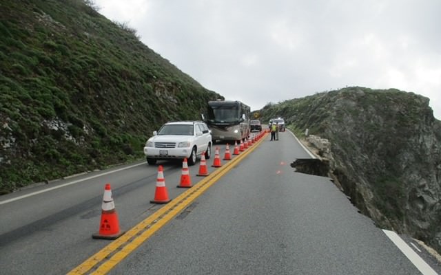
Convoys passing through northbound Highway 1 at the slip out south of the Rocky Creek Bridge on March 31.
###
Estimated reopening Highway 1 at Paul’s Slide is for late Spring 2024.
See latest Caltrans Press Release below the map.
Travelers in the Morro Bay - Cambria area will be able to travel north for over 47 miles from Cambria on Hwy. 1 until they encounter the turnaround at Limekiln State Park. All coastal businesses remain open.
As you can see on the map below Big Sur is separated into the northern section and the southern section. If you are coming from the south and want to visit the northern section you'll need to take Highway 101 to Highway 68 west (near Salinas) to Highway 1 south from Monterey. If you are coming from Los Angeles, this route adds only about 35 minutes to your drive. If you are coming from the north driving directions are as usual
To visit the southern section from the south, take Highway 101 north to Highway 1 and continue north.
To visit the southern section and then detour around to visit the norther section, take Highway 46 east to Highway 101 north, to Highway 68 west, to Highway 1 south to Big Sur. Reverse this if coming from the northern section.
Nacimiento-Fergusson Road remains closed for repairs.
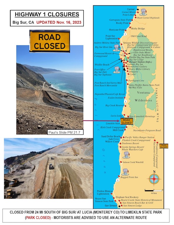
Download PDF of this map for an expanded view

Date: Friday, December 8, 2023
District: 05 – Santa Barbara, San Luis Obispo, Monterey, San Benito, and Santa Cruz Counties
Contact: Kevin Drabinski or Jim Shivers
Phone: (805) 549-3138 or (805) 549-3237
FOR IMMEDIATE RELEASE
UPDATE #52
ESTIMATED REOPENING OF HIGHWAY 1 AT PAUL’S SLIDE
SET FOR LATE SPRING 2024
MONTEREY/SAN LUIS OBISPO COUNTIES – Caltrans today announced an estimated date for a full reopening of Highway 1 at Paul’s Slide of late spring 2024.
This estimated reopening is based on multiple months of work still needed to complete repairs at the site. Tasks that still remain include:
• The continued grading and contouring of the face of the slide to enhance stability of the slope.
• Continued delivery of fill material to the south end of the repair to support the new alignment of the road which will be elevated as much as 60 feet and slightly inland from its previous course. This new alignment also provides for an expanded catchment area on the inland side intended to keep future slide materials away from the roadway.
• Installation of a series of new culverts to convey water and debris under the roadway.
•Final surveys and paving of the road.
• Installation of protective rockfall barriers on the northbound side and guardrail in the southbound direction.
While Caltrans has confidence in the duration of the work necessary to complete the repairs, there is less certainty about how winter rains will affect this timetable.
Depending on the intensity and duration of a rain event, a single day of rain may delay production for multiple days. Production may be stopped to prepare the site in advance of forecasted rain. Once the rain event is over, resumption of production may be delayed due to saturation of the ground, or any damage caused by slide activity brought on by the rain.
Highway 1 remains closed to vehicle, bicycle, and pedestrian traffic for 1.5 miles, between Limekiln State Park to the south, and .6 miles south of the town of Lucia to the north.
Crews will continue to work seven days a week toward reopening of a road which the public can travel upon safely by late spring next year. Crews will continue to work in a manner which prioritize the safe working conditions of construction and maintenance crews.
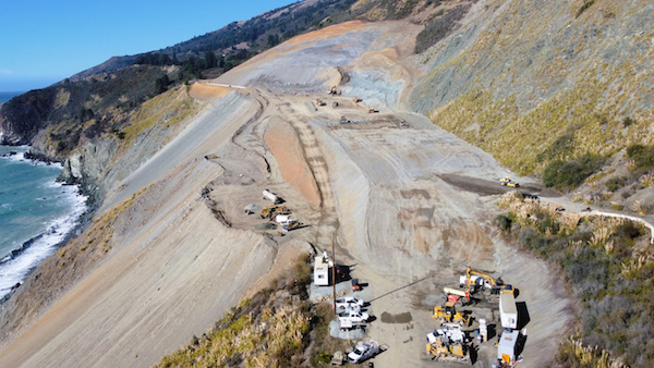
Work on Paul's Slide looking north taken 12/7/23
Date: Tuesday, November 14, 2023
District: 05 – Santa Barbara, San Luis Obispo, Monterey, San Benito, and Santa Cruz Counties
Contact: Kevin Drabinski or Jim Shivers
Phone: (805) 549-3138 (805) 549-3237
FOR IMMEDIATE RELEASE
UPDATE #51
CREWS CONTINUE TO MOVE FILL TO SOUTH END OF PAUL’S SLIDE TO SUPPORT NEW ELEVATION OF ROADWAY
MONTEREY/SAN LUIS OBISPO COUNTIES – Crews continue to work seven days a week on repairs at Paul’s Slide on Hwy. 1 on the Big Sur coast. Highway 1 remains closed to vehicle, bicycle, and pedestrian traffic for 1.5 miles, between Limekiln State Park to the south, and .6 miles south of the town of Lucia to the north.
Crews are building up the elevation of the south end of Paul’s Slide to support what will be the new course of the roadway. The repair design calls for the highway to move slightly inland and to be elevated at the southern approach.
The repair design will also increase the catchment area on the inland side of the highway which will be separated from the roadway by concrete barriers and fencing.
Geotech and hydrological engineers have completed the drainage design for the repairs which will capture water and debris and convey it below the roadway.
Due to dynamic conditions at the repair site as well as anticipated impacts associated with inclement weather in the upcoming months, there is no estimated time for full reopening of Highway 1 at Paul’s Slide at this time.
Road information and updates can also be found on Caltrans District 5 Social Media platforms: Twitter at: @CaltransD5, Facebook at: Caltrans Central Coast (District 5) and Instagram at: Caltrans_D5.
Big Sur mile markers
Map of Big Sur
Traveler information at: Caltrans QuickMap Page
Twitter https://twitter.com/CaltransD5
CHP Traffic Incident Information Page: http://cad.chp.ca.gov
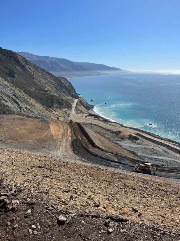
Views from atop Paul's Slide looking south
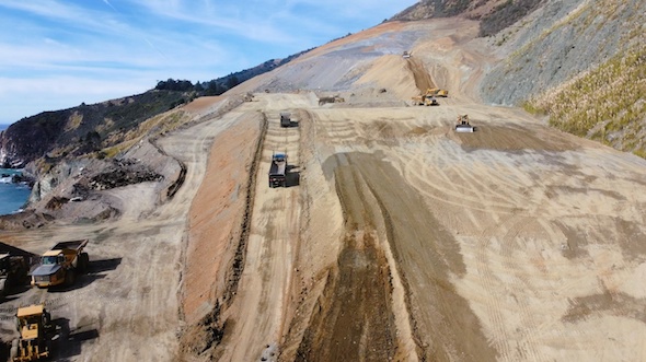
Crews continue to build up the elevation of the south end of Paul’s Slide for what will be the new course of the roadway.
Date: Friday, October 27, 2023
District: 05 – Santa Barbara, San Luis Obispo, Monterey, San Benito, and Santa Cruz Counties
Contact: Kevin Drabinski or Jim Shivers
Phone: (805) 549-3138 (805) 549-3237
FOR IMMEDIATE RELEASE
UPDATE #50
REPAIRS COMPLETE AT DANI CREEK SLIDE ON HIGHWAY 1 NORTHERN CLOSURE MOVED TO NORTH END OF PAUL’S SLIDE
MONTEREY/SAN LUIS OBISPO COUNTIES – Crews today completed final repairs at Dani Creek on Hwy. 1 where winter storms took out a large section of the roadway just north of Paul’s Slide. The northern closure of Hwy. 1 moved south today by .6 miles, from the town of Lucia to the north end of Paul’s Slide. The southern closure of Hwy. 1 remains at Limekiln State Park.
Travelers on southbound Hwy. 1 will pass the repair at Dani Creek and encounter a paved turnaround area at the north end of Paul’s Slide. There is no parking at this location. This movement of the northern closure will now provide travelers with direct access to the New Camaldoli Hermitage which was the last business affected by the closure at Dani Creek.
To make repairs at Dani Creek, crews created access in steep terrain down to the bottom of the slide, removed some 30,000 cubic yards of slide material, and built support from the bottom of the slide with fill material.
With compacted fill material in place, crews worked from the inland side of the road to bore through and place an 8-foot diameter culvert under the roadway. This culvert replaces one damaged during winter storms. Crews performed final paving, striping, and installation of guardrails over the last few weeks. Travelers may encounter intermittent traffic control in coming weeks as crews complete revegetation at the site.
Highway 1 remains closed to vehicle, bicycle, and pedestrian traffic for 1.5 miles, between Limekiln State Park to the south, and .6 miles south of the town of Lucia to the north.
Crews continue to advance with repairs at Paul’s Slide working seven days a week.
Due to dynamic conditions at the repair site as well as anticipated impacts associated with inclement weather in the upcoming months, there is no estimated time for full reopening of Highway 1 at Paul’s Slide at this time.
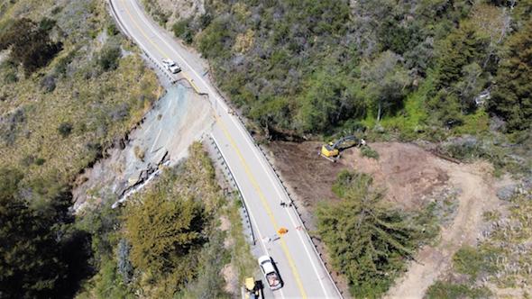
Winter 2023 damage to Highway 1 at Dani Creek
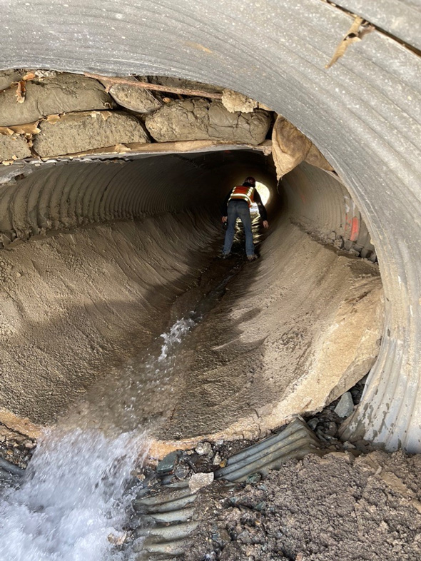
Damaged Culvert at Dani Creek, winter 2023
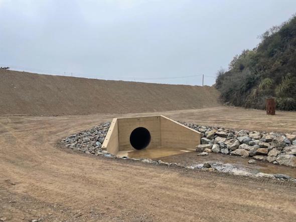
Eight-foot diameter culvert in place at Dani Creek repair
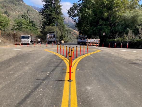
Turnaround on Highway 1 at north end of Paul's Slide, some .6 miles south of the town of Lucia
Date: Tuesday, October 3, 2023
District: 05 – Santa Barbara, San Luis Obispo, Monterey, San Benito, and Santa Cruz Counties
Contact: Kevin Drabinski or Jim Shivers
Phone: (805) 549-3138 (805) 549-3237
FOR IMMEDIATE RELEASE
UPDATE #49
CREWS CONTINUE TO BUILD UP ROADBED FOR UPDATED REPAIR AT PAUL’S SLIDE ON HIGHWAY 1
MONTEREY/SAN LUIS OBISPO COUNTIES – Crews are working seven days a week at Paul’s Slide, moving enormous quantities of material throughout the site, and positioning fill materials needed to support the future alignment of the road.
The repair design anticipates a slight repositioning of the highway inland. The design also takes advantage of the shape of the mountain to create additional catchment area on the inland side of the road.
The catchment area will be separated from the northbound lane by concrete barriers and fencing, much in the way it had been for the last several years. The enlarged catchment area will have a greater capacity to collect slide materials and give maintenance crews additional room to work in when they clear debris.
Crews are also designing critical drainage infrastructure at the site which will be installed over the coming months.
Highway 1 remains closed to vehicle, bicycle, and pedestrian traffic for two miles, between Limekiln State Park to the south and the town of Lucia to the north.
Due to dynamic conditions at the repair site as well as anticipated impacts associated with inclement weather in the upcoming months, there is no estimated time for full reopening of Highway 1 at Paul’s Slide at this time.
Road information and updates can also be found on Caltrans District 5 Social Media platforms: Twitter at: @CaltransD5, Facebook at: Caltrans Central Coast (District 5) and Instagram at: Caltrans_D5.
Big Sur mile markers
Map of Big Sur
Traveler information at: Caltrans QuickMap Page
Twitter https://twitter.com/CaltransD5
CHP Traffic Incident Information Page: http://cad.chp.ca.gov
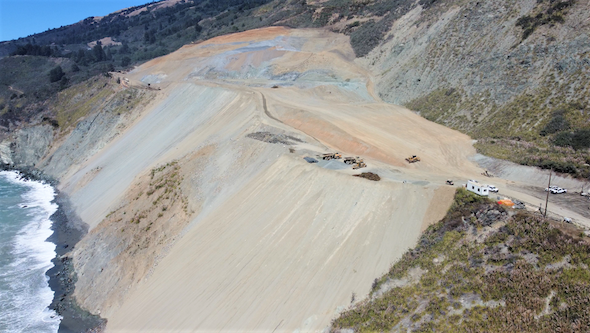
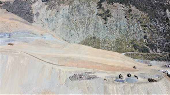
Aerial views of south end of Paul’s Slide showing materials being positioned to support the new alignment of the roadway.
Date: Tuesday, September 12, 2023
District: 05 – Santa Barbara, San Luis Obispo, Monterey, San Benito, and Santa Cruz Counties
Contact: Kevin Drabinski or Jim Shivers
Phone: (805) 549-3138 (805) 549-3237
FOR IMMEDIATE RELEASE
UPDATE # 48
REPAIRS CONTINUE AT PAUL’S SLIDE WITH UPDATED REPAIR DESIGN
MONTEREY/SAN LUIS OBISPO COUNTIES – After a brief reassessment in early August, crews have continued to engage in ongoing repairs to Highway 1 at Paul’s Slide. Highway 1 remains closed to vehicle, bicycle, and pedestrian traffic for two miles, between Limekiln State Park to the south and the town of Lucia to the north.
There have been two overriding safety priorities while working to fully reopen the highway. The first has been the safety of the crews who make these repairs while working at a site that is steep and where slide activity continues (and will continue) to take place.
The second goal has been to design a repair that will create a safe roadway for the travelling public.
With those safety priorities in mind, engineering teams have developed a repair design which will bring the roadway slightly inland as it passes in front of the Paul’s Slide complex. This design also allows for an enlarged catchment area between concrete barriers and fencing placed along the northbound lane and the toe of the slide. This will enhance safety for the travelling public as well as for construction and maintenance crews.
Crews are working seven days a week during all daylight hours. Because of uncertainty regarding continued slide activity at the repair site as well as weather conditions over the coming months, there is no current estimated time for a full reopening of Highway 1 at Paul’s Slide.
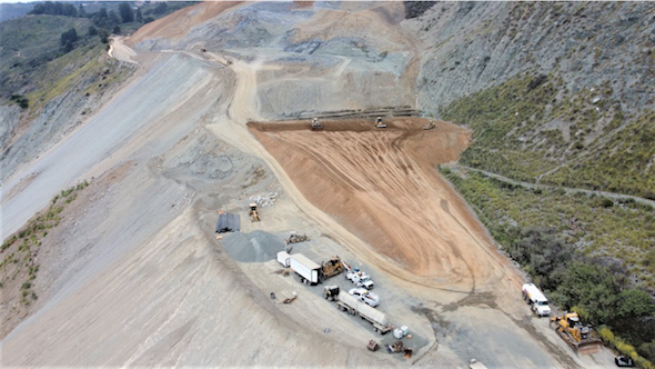
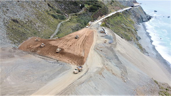

Date: Wednesday, August 2, 2023
District: 05 – Santa Barbara, San Luis Obispo, Monterey, San Benito, and Santa Cruz Counties
Contact: Kevin Drabinski or Alexa Bertola
Phone: (805) 549-3138 or (805) 549-3237
FOR IMMEDIATE RELEASE
UPDATE #47
GEOTECH INVESTIGATIONS TO DETERMINE NEXT STEPS AT PAUL'S SLIDE
MONTEREY/SAN LUIS OBISPO COUNTIES – Continued movement of the hillside has paused slide removal efforts at Paul's Slide. The result of current Geotech studies will help determine specific next steps for repair efforts.
Geotech crews continue to study measurements of recent slide activity and, in coordination with Caltrans engineering teams, will design repairs based on the assessment of these slide conditions.
Our approach continues to prioritize the safety of crews who have worked almost nonstop since late March to remove slide material and stabilize the hillside.
A two-mile closure of Highway 1 remains in effect between Limekiln State Park and Lucia. Highway 1 on the Big Sur coast remains open from Cambria to Limekiln, and from Monterey to Lucia.
Road information and updates can also be found on Caltrans District 5 Social Media platforms: Twitter at: @CaltransD5, Facebook at: Caltrans Central Coast (District 5) and Instagram at: Caltrans_D5.
Big Sur mile markers
Map of Big Sur
Traveler information at: Caltrans QuickMap Page
Twitter https://twitter.com/CaltransD5
CHP Traffic Incident Information Page: http://cad.chp.ca.gov
Date: Friday, July 21, 2023
District: 05 – Santa Barbara, San Luis Obispo, Monterey, San Benito, and Santa Cruz Counties
Contact: Jim Shivers or Alexa Bertola
Phone: (805) 549-3237 or (805) 549-3237
FOR IMMEDIATE RELEASE
UPDATE #46
NO ESTIMATE FOR REOPENING OF HIGHWAY 1 AT PAUL’S SLIDE
PENDING FURTHER GEOTECH INVESTIGATIONS
MONTEREY/SAN LUIS OBISPO COUNTIES – Due to recent continued slide activity at the repair site at Paul’s Slide, an estimate for a possible reopening date for Highway 1 will not be attempted until further Geotech investigations are completed.
Geotech teams continue to study drone imagery and other measurements of recent slide activity. The fact that the mountain continues to move makes a possible reopening date a moving target as well.
Crews have been working all daylight hours, seven days a week at Paul’s Slide since April of this year. The safety of our crews remains the first priority.
At this time, it is not known when a refreshed estimate for reopening the highway will be made. Further information on progress at Paul’s Slide and Dani Creek will be made as updates become available.
Two miles of Highway 1 between Lucia and Limekiln State Park remain closed due to the repair at Paul’s Slide. However, the entire segment of Highway 1 on the Big Sur coast from Cambria to Limekiln, and from Monterey to Lucia, remains open.
In addition, repairs to a major slip out at Dani Creek at PM 22.6 continue. Crews are focusing on the tunneling operation to install a culvert through the fill below the roadway with drilling work to begin next week. Repairs at Dani Creek are expected to continue through mid-September.
Road information and updates can also be found on Caltrans District 5 Social Media platforms: Twitter at: @CaltransD5, Facebook at: Caltrans Central Coast (District 5) and Instagram at: Caltrans_D5.
Date: Monday, July 3, 2023, at 7 p.m.
District: 05 – Santa Barbara, San Luis Obispo, Monterey, San Benito, and Santa Cruz Counties
Contact: Kevin Drabinski or Alexa Bertola
Phone: (805) 549-3138 or (805) 549-3237
FOR IMMEDIATE RELEASE
UPDATE #45
SOUTHERN CLOSURE OF HIGHWAY TO RETURN TO LIMEKILN TUESDAY MORNING JULY 4 FOLLOWING SINKHOLE REPAIR
MONTEREY / SAN LUIS OBISPO COUNTIES – The southern closure of Highway 1 will return to Limekiln State Park on Tuesday July 4, at 8 am.
This follows repairs to a sinkhole which appeared on July 2, one mile south of Nacimiento-Fergusson Road and which necessitated moving the closure five miles south to Pacific Valley.
Crews have repaired the sinkhole and addressed drainage issues at the site.
Travelers on Highway 1 will again be able to travel from Morro Bay north to Cambria, San Simeon, Ragged Point, Gorda, and on to Limekiln State Park. All coastal businesses are open.
Big Sur mile markers
Map of Big Sur
Traveler information at: Caltrans QuickMap Page
Twitter https://twitter.com/CaltransD5
CHP Traffic Incident Information Page: http://cad.chp.ca.gov
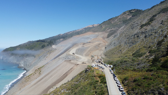
Paul's Slide
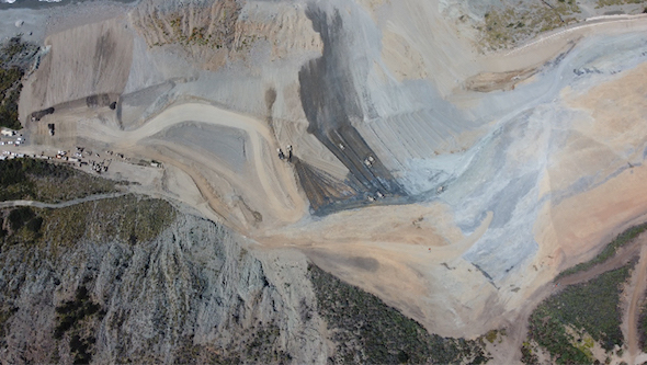
Paul's Slide
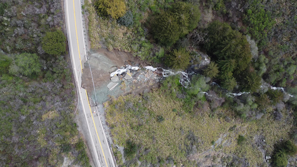
Dani Creek Slide
Date: Sunday, July 2, 2023
District: 05 – Santa Barbara, San Luis Obispo, Monterey, San Benito, and Santa Cruz Counties
Contact: Kevin Drabinski or Alexa Bertola
Phone: (805) 549-3138 or (805) 549-3237
FOR IMMEDIATE RELEASE
UPDATE #44
SINKHOLE ON HIGHWAY 1 MOVES SOUTHERN CLOSURE SOUTH TO PACIFIC VALLEY
MONTEREY / SAN LUIS OBISPO COUNTIES – The southern closure of Highway 1 was moved south today, from Limekiln State Park in Monterey County at Post Mile 21.2 to Pacific Valley at PM 16, due to a sinkhole which appeared on the center line of the roadway at PM 17.96.
The location of the sinkhole at PM 17.96 is one mile south of Nacimiento-Fergusson Road. The closure of Highway 1 at Pacific Valley provides adequate room for large vehicles and trucks to safely turn around.
Contracted crews are in route to the site to make assessments and begin repairs. Updates will be provided when the repairs are complete, and the southern closure can be moved north again to Limekiln.
Date: Friday, June 23, 2023
District: 05 – Santa Barbara, San Luis Obispo, Monterey, San Benito, and Santa Cruz Counties
Contact: Kevin Drabinski or Jim Shivers
Phone: (805) 549-3138 or (805) 549-3237
FOR IMMEDIATE RELEASE
UPDATE #43
NORTHERN CLOSURE OF HIGHWAY 1 MOVED SOUTH TO LUCIA
REPAIRS TO CONTINUE AT DANI CREEK AND PAUL’S SLIDE
MONTEREY / SAN LUIS OBISPO COUNTIES – The northern closure of Highway 1 on the Big Sur coast moved four miles south today, from the Big Creek Vista Point in Monterey County at Post Mile 27.3 to Lucia at PM 23.2.
With this move of the northern closure, a roughly two-mile stretch of Hwy. 1 remains closed to through traffic.
Travelers in the Monterey area will now be able to travel approximately 55 miles south on Hwy. 1 before encountering the turnaround at Lucia.
The southern closure of Hwy. 1 remains located at just before the entrance to Limekiln State Park at PM 21.2. Limekiln State Park remains closed to the public.
Travelers in the Morro Bay - Cambria area will be able to travel north for over 47 miles from Cambria on Hwy. 1 until they encounter the turnaround at Limekiln State Park. All coastal businesses remain open.
Repairs to a major slip out at Dani Creek at PM 22.6 continue. Crews have removed debris from the slip out area below the roadway and have been reconstructing the highway embankment which is approaching the previous level of the road. Crews will next focus on a tunneling operation which will drive a culvert through the fill below the roadway. Repairs at Dani Creek are expected to continue through August 17.
Crews are also continuing to work 12-hour shifts, seven days a week, at Paul’s Slide at PM 21.7. The current estimate for reopening the highway at Paul’s Slide is still several months. A refreshed estimate for a reopening date at Paul’s Slide will be made in mid-July.
Road information and updates can also be found on Caltrans District 5 Social Media platforms: Twitter at: @CaltransD5, Facebook at: Caltrans Central Coast (District 5) and Instagram at: Caltrans_D5.
Our crews deserve to get home safely too.
Drive slowly and carefully in work zones.
Big Sur mile markers
Map of Big Sur
Traveler information at: Caltrans QuickMap Page
Twitter https://twitter.com/CaltransD5
CHP Traffic Incident Information Page: http://cad.chp.ca.gov
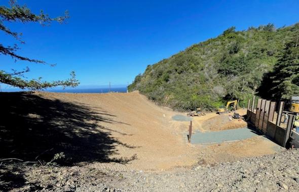
Date: Friday, May 26, 2023 - 3:30PM
District: 05 – Santa Barbara, San Luis Obispo, Monterey, San Benito, and Santa Cruz Counties
Contact: Kevin Drabinski or Jim Shivers
Phone: (805) 549-3138 or (805) 549-3237
FOR IMMEDIATE RELEASE
UPDATE #42
TWENTY-ONE MILES OF HIGHWAY 1 REOPENED AFTER REPAIRS FROM WINTER STORMS
MONTEREY / SAN LUIS OBISPO COUNTIES – Twenty-one miles of Highway 1 on the Big Sur coast reopened at 3 p.m. today, as the southern closure of Highway 1 moved north from Ragged Point in San Luis Obispo County, to just south of Limekiln State Park in Monterey County.
Travelers arriving at the new southern closure will be directed to a flagged turnaround area placed just before the entrance to Limekiln State Park. There is no parking at the turnaround area and entry into Limekiln State Park is prohibited and the Park is closed.
This reopening was made possible after crews repaired a major washout of the road at Gilbert’s Slide just north of Gorda at Post Mile 10.6. Crews also made significant repairs to distressed conditions at Radio Point at PM 4.9, at PM 0.8, and at the county line at PM 0.1.
Travelers on Highway 1 will continue to encounter signalized traffic control at PM 0.8 as crews complete drainage and guardrail work. Travelers may also encounter intermittent traffic control as repairs continue at various other locations.
Special recognition is made for the work of S. Chaves Construction whose crews have not only led the repairs of Highway 1 at the above locations, but at dozens of other areas of concern between Ragged Point and Limekiln.
Crews also continue to work at Paul’s Slide at PM 21.7. The current estimate for reopening the highway at Paul’s Slide is still several months. The massive undertaking to remove an estimated 500,000 cubic yards of material and to sculpt and stabilize the slope is being met by crews working 12-hour shifts, seven days a week. A more refined estimate for a reopening date at Paul’s Slide will be made in early July.
Repairs to a major washout of the road also continue at the Dani Creek Slide at PM 22.6, with work now estimated to be completed by mid-July.
Special recognition is also made for Papich Construction and their crews for taking the lead on repairs at Dani Creek, Paul’s Slide, and several other locations on the coast this winter.
Travelers in the Monterey/Carmel area will continue to be able to drive south for 50 miles to enjoy the splendor of the coast and will then encounter their turnaround at Big Creek Vista Point at PM 27.
Travelers in Morro Bay will now have over 65 miles of coast to enjoy to the north as Highway 1 passes through Cayucos, Cambria, San Simeon, Ragged Point, Gorda, and points beyond, before arriving at the turnaround south of Limekiln.
With the movement of the southern closure today, only five miles of Highway 1 remain closed from Big Creek Vista Point to just south of Limekiln State Park. All coastal businesses remain open.
Road information and updates can also be found on Caltrans District 5 Social Media platforms: Twitter at: @CaltransD5, Facebook at: Caltrans Central Coast (District 5) and Instagram at: Caltrans_D5.
Our crews deserve to get home safely too.
Drive slowly and carefully in work zones.
Big Sur mile markers
Map of Big Sur
Traveler information at: Caltrans QuickMap Page
Twitter https://twitter.com/CaltransD5
CHP Traffic Incident Information Page: http://cad.chp.ca.gov
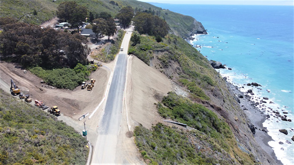
Repair at Gilbert’s Slide on Highway 1 north of Gorda, May 25, 2023
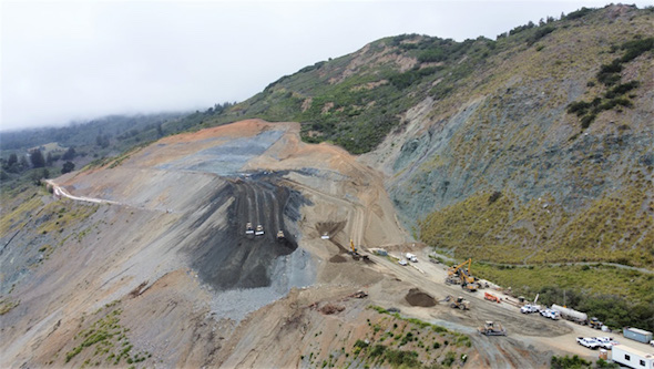
Top-down removal of material at Paul’s Slide on Highway 1, May 25, 2023
Click Here to see the photo attached to February 1 press release
CLICK HERE to see photos attached to January 27 press release
CLICK HERE to see photos attached to January 24 press release
See photos of the slide at The Big Sur Blog
USEFUL WEBSITE LINKS:
Big Sur mile markers
Restroom locations in Big Sur
Big Sur Mile Markers Map with Landmarks for Central Coast
Mile Marker Map PDF's with Landmarks
Big Sur Coast North
Big Sur Coast Central
Big Sur Coast South
THE DISPERSED CAMPING AREA OF PREWITT RIDGE AND THE SURROUNDING AREA IS CLOSED TO THE PUBLIC.
See Forest Order below:

FOREST ORDER NUMBER 05-07-51-22-06
LOS PADRES NATIONAL FOREST MONTEREY RANGER DISTRICT DOLAN FIRE ROAD CLOSURE
Pursuant to 16 U.S.C. § 551 and 36 C.F.R. § 261.50(a) and (b), and to provide for public safety, the following acts are prohibited within the Monterey Ranger District of the Los Padres National Forest. This Order is effective from April 30, 2022, through April 29, 2023.
1. Operating a motor vehicle on the following National Forest System roads, as shown on the attached map:
-
Forest Road No. 22S01 (Nacimiento-Fergusson Road) from its intersection with State Highway 1 to the western entrance of Nacimiento Campground;
-
Forest Road No. 20S05.4 (South Coast Ridge Road) from its intersection with Forest Road No. 22S01 (Nacimiento-Fergusson Road) to its intersection with ForestRoad No. 22S04 (Prewitt Ridge Road); and
-
Forest Road No. 20S05.3 (Central Coast Ridge Road / Cone Peak Road) from its intersection with Forest Trail No. 3E10 (North Coast Ridge Trail) to its intersection with Forest Road No. 22S01 (Nacimiento-Fergusson Road).
36 C.F.R. § 261.54(a).
Pursuant to 36 C.F.R. § 261.50(e), the following persons are exempt from this Order:
-
Any Federal, State or Local Officer or member of an organized rescue or fire-fighting force in the performance of an official duty.
-
Persons with Forest Service Permit No. FS-7700-48 (Permit for Use of Roads, Trails, or Areas Restricted by Regulation or Order) specifically exempting them from this Order.
-
Owners or lessees of private land within the boundaries of the Los Padres National Forest, to theextent reasonably necessary to gain access to their land.
-
Persons with a U.S. Forest Service contract, special use permit, or partnership agreement authorizing work on the closed roads or closed recreation site, and their employees, sub- contractors, and agents, to the extent necessary to perform the authorized work.
-
Employees, contractors, agents, and cooperators of the Department of Plant Pathology, University of California at Davis, who are conducting research on Sudden Oak Death pursuant to Agreement No. 19-DG-11052021-209, to the extent reasonably necessary to gain access to research plots within the Dolan Fire footprint.
This Order supersedes Order 05-07-51-21-19, dated October 27, 2021
These prohibitions are in addition to the general prohibitions contained in 36 C.F.R. Part 261, Subpart A.
A violation of these prohibitions is punishable by a fine of not more than $5,000 for an individual or $10,000 for an organization or imprisonment for not more than six months or both. 16 U.S.C. § 551and 18 U.S.C. §§ 3559, 3571 and 3581.
Executed in Solvang, California this 29th day of April 2022.
ANTHONY EDWARDS Acting Forest Supervisor Los Padres National Forest
DOWNLOAD THIS PRESS RELEASE PDF
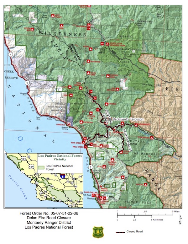
DOWNLOAD THIS MAP PDF
Helpful blogs and links:
County Road Closures (information about Nacimiento-Fergusson Road)
California Highway Patrol Incident Information
California Department of Transportation

Download our local Big Sur Visitors Guide PDF.

|