|
An Overview of the Esselen Indians of Monterey County
by Gary S. Breschini, Ph.D. and Trudy Haversat, M.A.
Inside a cave in a narrow canyon near Tassajara
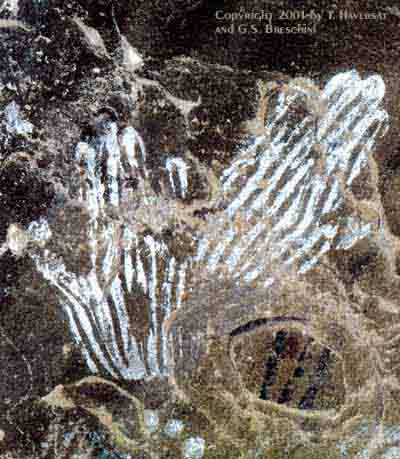
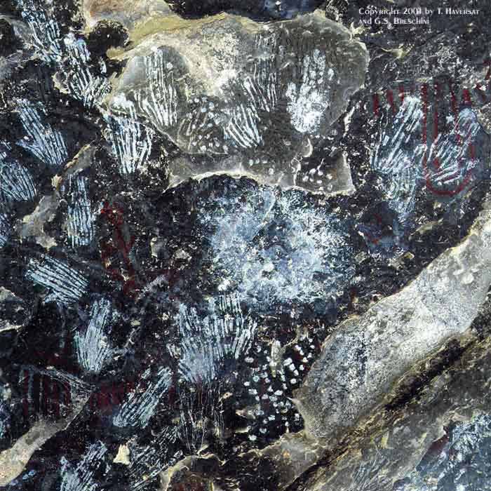
The vault of rock is painted with hands,
A multitude of hands in the twilight, a cloud of men’s palms, no more,
No other picture. There’s no one to say
Whether the brown shy quiet people who are dead intended
Religion or magic, or made their tracings
In the idleness of art; but over the division of years these careful
Signs-manual are now like a sealed message
Saying: "Look: we also were human; we had hands, not paws. All hail
You people with cleverer hands, our supplanters
In the beautiful country: enjoy her a season, her beauty, and come down
And be supplanted; for you also are human."
— Robinson Jeffers (1887-1962)
Introduction
The Esselen were one of the least numerous groups in California, and are often cited as the first California group to become culturally extinct. Some have placed cultural extinction early as the 1840s (Kroeber 1925:544; Hester 1978:497; Beeler 1978:3). Reasons cited generally include the small size of the group, and close proximity of Esselen territory to two of the three earliest California Missions.
This picture of Esselen extinction, although pervasive in the literature, is wrong. There is recent evidence that some Esselen may have escaped the missions entirely by retreating to the rugged interior mountains. It appears that a small group may have survived into the 1840s before filtering to the ranchos or the outskirts of the growing towns. Also, some traditions have been passed down from generation to generation.
In spite of recent advances, relatively little is known about many aspects of Esselen culture and prehistory. The following is a brief overview assembled from a number of sources, most of which are included under "Sources" below.
Territory and Geographic Setting
In order to understand the Esselen it is first necessary to place them within the context of their geographic setting. When they were "discovered" by the Spanish over 200 years ago, the Esselen lived in the upper Carmel Valley, in the rugged and densely-forested Santa Lucia Mountains, now a part of the Los Padres National Forest. Much of Esselen territory is now included within the Ventana Wilderness area. (See map.)
The Santa Lucia Mountains are extremely rugged, characterized by jagged peaks and steep canyons. The portion of the coast controlled by the Esselen generally lacks wave-cut terraces; it consists largely of high steep cliffs cut by small coastal creeks. Traveling north and south along the coast would have been extremely difficult. It is most likely that such journies involved traveling inland to the crest of the coast ridge, and then following that ridge north or south.
In studying the Esselen, the nature of the terrain must constantly be kept in mind. The rugged terrain in which they lived contributed to their way of life. Other than the obvious restrictions which the terrain would impose upon their settlement patterns and subsistence strategies, it would have also affected trade and communication with their neighbors, and influenced their lives in a multitude of more subtle ways. For example, the partial isolation of the Esselen probably contributed to the degree of linguistic distinctness noted by Kroeber, as well as the distinctness of Esselen culture.
Political Geography
According to Milliken (1990:59) there were five Esselen districts: Excelen, Eslenahan, Imunahan, Ekheahan, and Aspasniahan (see map). Each of these districts occupied a fairly specific territory with generally-recognized boundaries, and most likely had a reasonably stable resident population. Within each district there were a number of villages which were sequentially occupied on a seasonal basis depending on the availability of resources such as food, water, shelter, and firewood. Of these five districts, the boundaries of the Excelen district are probably the best known. The least known boundaries are in the mountainous areas between Excelen, Imunahan, and Ekheahan.
Population
Kroeber (1925:545) estimated that the Esselen population was between 500 and 1,000, probably closer to 500. Cook initially placed the Esselen population at 750 (1943:186), but subsequently revised his estimate to over 1,300 (1974a:11). Cook's estimate of at least 1,300 was based partially on the assumption that the Esselen occupied a territory of 625 square miles with a population density of 2.1 individuals per square mile. Cook's mission record research identified approximately 951 Esselen baptisms, but his figures included Sarhentaruc. Using a multiplication factor 1.5 to account for the difference between the number of baptized individuals and the actual population, Cook arrived at an aboriginal population between 1,300 and 1,425 for the Esselen and Sarhentaruc areas. When Sarhentaruc is removed the population drops to about 1,185.
Milliken (1990) argues that Sarhentaruc should not be included within Esselen territory. Milliken's baptism counts for the five Esselen districts (excluding Sarhentaruc) included 856 individuals. If, as Cook suggests, a multiplication factor of about 1.5 is applied, a total population of about 1,285 is reached. This is in reasonably close agreement with Cook's estimates.
Milliken estimates Esselen territory at about 750 square miles (including Sarhentaruc). Subsequent research (Breschini and Haversat 1994) provides an estimate closer to 800 square miles (excluding Sarhentaruc) or 850 square miles (including Sarhentaruc). Using Milliken's population estimate of 1,285 yields a population density of about 1.5 or 1.6 persons per square mile. Given the rugged nature of the Esselen territory, this may be a more reasonable figure than Cook's 2.1 persons per square mile.
Linguistic Classification
More to come.
Rock Art

Click here to see a larger version of the Esselen handprints rock art
The Esselen are known for the unique handprints which are found in two areas--Pine Valley and a valley to the southeast (see map). More will be added about these unique handprints shortly.
The information on this page was generously supplied by Gary S. Breschini, Ph.D. and Trudy Haversat, M.A. More information about the Esselen Indians and other tribes of Monterey County can be found at www.esselentribe.org
Sources:
* Beeler, M.S., Esselen (The Journal of California Anthropology Papers in Linguistics, Malki Museum, Banning, CA, 1978).
* Breschini, G.S. and T. Haversat, An Overview of the Esselen Indians of Central Monterey County, California (Coyote Press, Salinas, CA, 1994).
* Cook, S.F., The Esselen: Territory, Villages, and Population (Monterey County Archaeological Society Quarterly 3(2), Carmel, CA, 1974a).
* Cook, S.F., The Esselen: Language and Culture (Monterey County Archaeological Society Quarterly 3(3), Carmel, CA, 1974b).
* Culleton, James, Indians and Pioneers of Old Monterey (Academy of California Church History, Fresno, CA, 1950).
* Hester, T.R., Esselen (in California, ed. by R.F. Heizer, pp. 496-499. Handbook of North American Indians, vol. 8, W.G. Sturtevant, general ed. Smithsonian Institution, Washington, D.C., 1978).
* Kroeber, A.L., Handbook of the Indians of California (Bureau of American Ethnology Bulletin 78, Washington, D.C., 1925).
* Milliken, R., Ethnogeography and Ethnohistory of the Big Sur District, California State Park System, During the 1770-1810 Time Period (submitted to Department of Parks and Recreation, Sacramento, CA, 1990).
Copyright 2001 by G.S. Breschini and T. Haversat
All Rights Reserved.
------------------------------------------------------------------------
Copyright 2001. All rights reserved. ESSELEN TRIBE, ESSELEN TRIBE OF MONTEREY COUNTY, ESSELEN.COM, the ESSELEN MASTHEAD and HANDPRINT LOGO are all trademarks of the Esselen Tribe of Monterey County.
|

